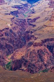
The Himalayan orogeny or mountain formation is an ongoing process began from Cenozoic era from collision of tectonic plates and it had profound impact on the climate and ecosystem of the region.

Himalayas – the evolution
The Himalayan orogeny is a complex process of mountain building that happened through millions of years and is still ongoing. This article by dr sanjana p souparnika is an in-depth study of the evolution of Himalayas, the majestic mountain ranges over the centuries.
The word “orogeny” is derived from Greek and it means “mountain creation”. Orogeny is the primary geological process of mountain building happening through the collision of tectonic plates on the earth’s crust at convergent margins. This collision leads to intense folding, faulting, and crustal thickening processes. It lifts, deforms, and metamorphoses crustal material to create huge mountain ranges like the Himalayas. The Himalayas were formed around 50-100 million years ago in the Cenozoic era.
Himalayan orogeny deciphers the evolution of species
The formation of Himalayas began roughly 50–70 million years ago and the Himalayan stratigraphic study of rocks may decipher plate tectonic movements in the geological time scale along with changes in climate and biodiversity in the region around Himalayas. This can throw light into the history of evolution of earth & its ecosystems over billions of years.
The collision of the Indian and Eurasian continental plates paved way for the Himalayan mountain building and still it is ongoing. This collision vanished the Tethys ocean[ an ancient ocean] resulting in intense folding, faulting, and crustal thickening, ultimately forming the Himalayas.
The Cenozoic Era is the current and most recent geological era, spanning from 66 million years ago to the present day. It is also known as the “Age of Mammals”. We must remember that only 2.6 million years ago humans appeared on the surface of earth from hominids through the evolutionary process. The Homo Sapiens emerged precisely in the quaternary period of coenozic era, in the Pleistocene epoch around 300,000 years ago. In that sense, Himalayas being the youngest mountain ranges formed in the Cenozoic era has profoundly influenced the climate and ecosystems and emergence of human species.
Himalayan rock stratigraphic studies unveil the influence of mountain ranges in the evolution of human species. The rapid uplift of Himalayan mountain ranges as a result of collision of tectonic plates created new ecological niches. Ecological niches are specific environmental requirement of a species within an ecosystem such as habitat, food sources etc. that help survival and reproduction. These niches acted as a “species pumps” that instigated significant evolutionary changes through diversification, and vicariance of Asian fauna and flora.
When an ecological niche is empty with no living organisms, particularly after a new landform creation or extinction, it acts as a “pump” that attracts new species into it. The niches, allowing for the evolution of specialized, endemic species.
However, it is to be noted that, according to the competitive exclusion principle, two species with identical niches cannot coexist; one species may compete with the other, eventually leading to extinction. Nevertheless, nearly identical species clusters may co-occur sometimes.
In short When niches are differentiated, they reduce competition between species and fosters coexistence of similar species.
Himalayan mountain uplift enhanced biodiversity
The orogeny of Himalayas has immensely impacted the biodiversity through intense topographic and climatic changes.
Himalayas created diverse habitats, stimulating diversification and rapid evolution of species of fauna and flora. Diversification is the evolutionary process where species adapt to fill specific roles in an ecosystem, reducing competition and increasing biodiversity.
The newly formed mountain ranges created physical barriers, fragmenting populations and leading to allopatric speciation through vicariance. vicariance denotes a scenario where a species is divided by a geographical barrier may adapt to slightly different environmental conditions. The passive splitting of a species’ range, often due to geological changes such as mountain uplift, continental drift or climatic changes lead to vicariance. This process has crucial role in allopatric speciation. Here the physical isolation of the species in a new ecological niche leads to genetic and phenotypic divergence. Himalayan niches thus grow as great biodiversity spots.
The uplift of Himalayan ranges intensified the South Asian Monsoon, which had impacted the regional climate and determined the expansion or contraction of habitats facilitating species movement and adaptation. The sudden uplift of mountains leads to environmental shifts either species adapting to the terrains or becoming extinct.
Himalayas- phases of orogeny
Himalayan mountain building phases
The Himalayan mountain range and Tibetan plateau have been formed from the collision between the Indian Plate and Eurasian Plate which happened around 40 and 50 million years ago. The tectonic plate movement and orogeny is still ongoing moving the plates towards north every year slightly.
The Himalayas are denoted as the youngest mountain chain in the world. Himalayan mountains have come out of the Tethys Sea and that the uplift has taken place in different phases.
During Permian Period (250) million years ago, there was a supercontinent known as Pangaea. Its northern part included present-day North America and Eurasia (Europe and Asia) which is called as Laurasia. The southern part of Pangaea consisted of present-day South America, Africa, South India, Australia, and Antarctica and together it was called Gondwanaland.
Between Laurasia and Gondwanaland,existed a long, narrow, and shallow sea known as the Tethys Sea with several tributaries of rivers flowing into it. Sediments from these rivers flowed in and deposited on the floor of the Tethys Sea.
Then the powerful compression due to the northward movement of the Indian Plate compressed the sediments of the sea bed. This resulted in the folding of sediments. As the Indian plate began plunging beneath the Eurasian plate, these sediments were further folded and uplifted resulting in the formation of Himalayas. Later the folded sediments, underwent weathering and erosional activity which sculpted it as the present-day Himalayas.
The genesis of Indo-Gangetic plain was due to the consolidation of alluvium brought down by the rivers flowing from the Himalayas.
Still the summit of Mount Everest is made of marine limestone from this ancient ocean tethys. Tibetan plateau was formed due to up thrusting of the southern block of the Eurasian Plate.
The movement of tectonic plate is an ongoing process happening even today. India is moving northwards at the rate of about five cm per year and crashing into the remaining part of Asia.
The curved shape of the Himalayas convex to the south is because of the maximum force occurred at two ends of the Indian Peninsula during its northward drift.
The orogeny of Himalayas into the current landform happened through 6 phases.
6 phases involved in the formation of Himalayas
Phase 1 – 100 million years ago
Phase 2 – 71 million years ago
Phase 3 – The Drass volcanic arc
Phase 4 – Greater Himalayas were raised
Phase 5 – Rise of lesser Himalayas
Phase 6 – Rise of the Shiwalik ranges
Phase 1
The first phase of formation of Himalayas began 100 million years ago During Cretaceous Period, around 100 million years ago, the Indian plate was located b/w 10 ⁰ S – 40 ⁰ S, over the reunion hotspot. The movement of the plate gathered its mass velocity as it was closer to the equator (14cm/yr) and compression of sediment bed of the Tethys sea started towards the end of the Paleocene.
Phase 2
The second phase of Himalayan orogeny began around 71 million years ago as the plate with Gondwana land drifted towards North East and the rigid Northwestern ridge composed of the Aravalli series collided with Eurasia.
The line of collision b/w the Tibetan Plateau and the Indian Plate is called Indus–Tsangpo Suture Zone which is a compressional tectonic fault line.
As the plate began to subduct, crustal doubling below Tibet raised them into a high plateau with a thickness of around 60km
Along the southern front of the Indus-Tsangpo Suture Zone, the Murree Foredeep was formed and further south, the Shiwalik foredeep was created.
Phase 3 – The Drass volcanic arc
During Oligocene period of Cenozoic era, the Drass volcanic area was formed and in the Tethys crust, a series of volcanic eruptions took place. It is situated in the Indus suture zone as an island arc on Neo- Tethys Ocean crust during cretaceous period[ 84-125 million years ago]
The plate has started anti-clock rotation and Drass became the Pivotal Axis. Thus, in the western part, pressure and compression were gradually released but towards the East, compression of Tethyan sediments has started which marks the beginning of the rising of Tethyan Himalayas. As the Indian plate pushed north 71-50 million years ago the sedimentary stack was thrust southward.The Tethys Himalayas originated from the sedimentary basin underwent folding and transformation during the period of compression.
Phase 4 – Greater Himalayas were raised.
The continuous rotation and greater compression created a major thrust in the sediments of Murree foredeep and greater Himalayas were raised about 30-35 million years ago (Oligocene to Eocene period]. The compressional thrust line is known as the Main Central Thrust (MCT). It is a 30-km-thick, medium- to high-grade metamorphic sequence of metasedimentary rocks which are interlocked by granites of Ordovician and early Miocene age.
However, majority of the meta sediments of this area of mountain ranges are of late Proterozoic to early Cambrian age.
The metasediments represent the metamorphic equivalents of the sedimentary series forming the base of the overlying “Tethys Himalaya“.
Phase 5 – Rise of lesser Himalayas
The sediments were being deposited in the Shiwalik foredeep and further movement in the plate formed the lesser Himalayas during the Miocene (15-20 million years ago.)
MCT separates greater and lesser Himalayas and the compressional thrust line along which the lesser Himalayas were lifted is known as Boundary Thrust/Fault (MBT of MBF) line.
Phase 6 – Rise of the Shiwalik ranges
In the Shiwalik foredeep, sedimentation by the Himalayan rivers formed the molasse material. It forms the southern foothills of the Himalayan Range and is essentially composed of Miocene to Pleistocene molassic sediments derived from the erosion of the Himalaya.
The partial feeding of the Shiwalik foredeep along the Himalayan Frontal Fault (HFF) led to the rise of the Shiwalik ranges which represent partially folded sedimentary range.
These molasse deposits, known as the “Murree and Sivaliks Formations”, are internally folded and imbricated.
Tethys Himalaya (TH) – A short narrative about the oldest mountain ranges of Himalayas
Tethys Himalayas represents the ocean to mountain transformation and therefore the fossils of marine organisms are found on its higher peaks with in sedimentary rocks. This region is also referred to as Tibetan zone Himalayas which covers Zanskar range in Kashmir and Spiti basin in Himachal Pradesh extending to south Tibet.
Tethys Himalayan region is located south of Indus Sangpo suture zone and north of Greater Himalayas. It is considered as the oldest parts of Himalayan range system. This zone of Himalayas originated from the seabed sediments of the ancient Tethys ocean [ an ancient ocean which got vanished by tectonic plates collision into huge mountain ranges of Himalayas].
The Tethys Himalaya is an approximately 100-km-wide synclinorium or trough formed by strongly folded and imbricated, weakly metamorphosed sedimentary series. It is 2000km long geological tectonic zone north of the main Himalayan range.
This zone has fossil remnants of northern margin of the Indian subcontinent.
Several nappes [ sheet like body of rocks], known as the “North Himalayan Nappes”, have also been described within the Tethys Himalaya which is a syclinorium of folded poorly metamorphosed fossiliferous marine sedimentary rocks [over 500 million years old].
Tethys mountain ranges give a stratigraphic record ranging from the Upper Proterozoic to the Eocene of fossils preserved within the sediments of the Tethys Himalaya. Stratigraphic analysis of Tethys Himalayan sediments yields important clues about the geological history of the northern continental margin of the Indian sub-continent. This mountain range gives implications about its Gondwanian evolution to its continental collision with Eurasia.
written by dr sanjana p Souparnika
image courtesy freepik.com