Raipur, the capital city of Chhattisgarh ,India is well- known for its green and cleanest city status as well as for its heritage. The city offers numerous tourist and pilgrim destination,falls, zoo, museums and the urban city life with numerous institutions of education &technology.
Ancient history of Raipur
Raipur, the heritage capital of Chhattisgarh was once known as Dakshina Kosala and was under the reign of Maurya Empire. A Gupta inscription dated to the 6th century CE discovered from Arang delineates the story of Gupta hegemony over the region.
According to historical texts in the 7th century CE, the region came under the reign of a Buddhist kingdom in Bhandak in modern-day Maharashtra. A sect of this royal family seems to be migrated to Sirpur [Mahasamund district] and conquered the entirety of Dakshina Kosala.
The glory of this ancient city reached its zenith during the rule of Tivaradeva. His son inscribed almost all temples in Sirpur.
According to archeological data,by the early 9th century the Kalachuris had hegemony over the region. The Kalachuris of Ratnapura ruled Ratnapur until the 13th century. By the 14th century, the Kalachuris of Raipur branch came into prominence.
Chief tourist destinations in Raipur
The Ghatarani waterfalls & Jatmai temple
It is located just 85 km from Raipur and the waterfall is one of the largest falls in Chhattisgarh. The waterfall has a mythological linking with the nearby Jatmai Ghatarani Temple, a holy temple dedicated to the goddess Ghatarani who symbolizes fertility and well-being. The shrine dates back to 18th century and is linked to Kalkanjari Devi.
The waterfall and this temple are the favourite spots for pilgrim tourists visiting Chhattisgarh. It is located at the Abhanpur Tehsil of Raipur and a favorite destination for adventure enthusiasts and trekking lovers. Post monsoon season [ November- February] is the most favourable season for travelling to Raipur and enjoy the beauty of these majestic waterfalls.
The Nandan van zoo
It incorporates a vast 800-acre wildlife, zoological park, and rescue center established in 1979. It features four main safaris—herbivore, bear, tiger, and lion—along with a dedicated zoo area within buses.
The cultural hub of purkhouti muktangan.
It portrays the tribal art and culture of Chhattisgarh with sculptures and artefacts.
The mahant ghasidas memorial museum
the Mahant Ghasidas Memorial Museum was established in 1875 and it offers deep insights into the region’s heritage. This museum offers anthropological & natural history artifacts, pottery & sculptures.
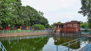
The Vivekananda sarovar
It is also known as Budha Talab, which is a lake in Raipur. It is located in Budhapara area near the Balbir Singh Juneja Indoor Stadium and it is spread in 30 hectares. The lake is named after the great Indian philosopher Swami Vivekananda who visited Raipur in 1897 and it is believed that he took a bath in this lake.
The Nava raipur
Nava Raipur [Atal Nagar-Nava Raipur] is a planned city and fully Greenfield city in Indian state of Chhattisgarh. This green city is located between National Highway 53 and National Highway 30, about 17 km south-east of the capital city Raipur. Swami Vivekananda Airport separates Raipur and Nava Raipur.
This beautiful city has various industries of gold ornaments, software and IT parks along with Botanical Garden, art gallery and symbols of heritage of the city. It is also a hub of educational institutions.
Cultural heritage of Chhattisgarh
Chhattisgarh possess a rich cultural heritage of folk music and dance. Pandwani dance is a well-known art form of Chhattisgarh. The state celebrates various cultural festivals including Chakradhar Samaroh, Sirpur Mahotsav, Rajim Kumbh, and Bastar Lokotsav.
Furthermore, the state of Chhattisgarh fosters many traditional art and crafts and artisans doing them. The state is renowned for its traditional ornamental designs including kardhan, phully, painjna, bidhu, tora, and maldar.
The indigenous food of Chhattisgarh include Muthia (steamed rice dumplings), Farra, Chilla, Aamat, and Bara.
How to reach Raipur?
Swami Vivekananda International Airport, (Formerly called the Mana Airport), is the main airport serving the state of Chhattisgarh. The airport is situated 15 km south of Raipur and 10 km from Naya Raipur. The airport provides direct flights to various Indian cities daily.
Raipur Junction Rai way station is well-connected with the Mumbai-Howrah main line.
The city is well-connected via NH 53 to major nearby states.
Kangra fort is a historically significant ancient fort in the Kangra district of the Himachal Pradesh state in India. The fort is the largest and one of the oldest forts in the Indian Himalayan range. It is believed to have been constructed by the Katoch dynasty in the 4th century BC.
Kangra -an ancient fort in the lap of Himalayan valley where history of centuries-old conquests sleeps…
Himachal Pradesh, a state in the Himalayan range of India boasts a rich heritage, encompassing historical monuments, religious sites, and a vibrant culture. Its main heritage sites include the UNESCO World Heritage Site Great Himalayan National Park, the Kalka-Shimla Railway, and the historic Kangra Fort.
Kangra fort is a historically significant ancient fort in the Kangra Valley, Himachal Pradesh, protected by archaeological department govt of India. The fort is popularly known as ‘Nagarkot’ and ‘Kot Kangra’.
This fort is one of the largest and oldest for in the Himalayan valley. It is situated on a hillock between two rivers Manjhi and Banganga among the foothills of the Dhauladhar range.
Kangra was once an important center of Jainism. The ancient remains or relics inside the fort are of Jain and Hindu temples dated to c. 9-10 century A.D.The earliest mention about kangra fort in the records dates back to the time of invasion of the fort by Mahmud Gazni in 1009 AD. Later the fort was seized by Muhammad bin Tughlug in 1337 AD. and succeeded by Firuz Shah Tughlug in 1351 A.D. respectively.
The structural characteristics of kangra
The Kangra Fort is spread across 463 acres in the Himalayan valley. The entrance to the fort is through a small courtyard enclosed between two gates. It is believed that this area was built during the Sikh period, as depicted by an inscription over the entrance. Soon the entrance area may lead to a long and narrow passage further pointing to the top of the fort, through the Ahani and Amiri Darwaza built by Mughals.
About 500 feet from the outer gate the passage turns round at a very sharp angle and passes through the Jehangiri Darwaza.
The Darsani Darwaza, which is now flanked by defaced statues of River Goddesses Ganga and Yamuna gave access to a courtyard, along the south side of which stood the stone shrines of Lakshmi-Narayana and Ambika Devi and a Svetambara Jain temple with large idol of Rishabhanatha
The myths & history surrounding Rishabanada Jain temple of kangra fort
The Jainist temple of the fort has to unveil a curious and enchanting myth or tale. According to a local legend, King Susarmacandra, came to know about the significance of Mount Shatrunjaya, and later he took a vow to not eat or drink anything until he pays homage to Rishabhanatha at Palitana temples. It is believed that immensely pleased by the king’s devotion and determination and to save him from his vow to starve, demigoddess Ambika created a temple of Rishabhanatha at the king’s fort. After paying homage to the idol, the king broke his fast.
Within the premises of Kangra Fort lies an idol of Rishabhanatha. The inscription on the pedestal of the idol is in Sarada script. It mentions that the idol was consecrated by Jain sect Svetambara monk Amalacandra, a disciple of Acarya Abhaycandra in 854 CE.
The granite idol of Rishabhanatha is seated in Padmasana posture. An icon of bull carved on its pedestal indicates that the idol is of Rishabhanatha. However, another noteworthy feature of this idol is that it does not show a waistband and a waistcloth, as most commonly found in Svetambara [Jainist monks] icons of Tirthankaras after Bappabhattisuri’s era.Locks of hair carved on both sides of the head of the idol as well as an inscription from 854 CE, however, substantiate that the idol and the temple is of the Svetambara sect of Jainism as noted by archaeologist Sir John Marshall.
It is an astonishing fact that, this ancient bustling Jain centre fade into oblivion after migration of Jainas out of the town. The idol of Rishabhanatha was found in the Indresvara Temple. Later on, efforts to reinstall the idol were made by Svetambara Jaina nun Mrugavati. After many decades, in 1978, the idol was installed in an independent shrine within Kangra Fort. Currently, the idol is under the supervision and control of the Archaeological Survey of India. However, it is maintained as a Jain temple and Jain devotees are given the right to worship the idol.
History of Kangra fort – story of invasions & siege by Mughals & retrieval by katoch dynasty
It is the largest fort in the Himalayas and probably the oldest dated fort in India. The Kangra Fort was built by the royal Rajput family of Kangra State the Katoch dynasty, which traces its origins to the ancient Trigarta Kingdom, mentioned in the Mahabharata epic. Later years witnessed invasion by Muslim rulers in their conquest of the subcontinent which lasted many centuries.
The earliest recorded reference to the Kangra fort dates from the time of this fort’s invasion by Mahmud Ghazni in 1009 A.D. The fort was captured by Muhammad bin Tughluq in 1337 A.D., and by his successor Firuz Shah Tughluq in 1351 A.D. respectively. Khawas Khan Marwat, a superior General of Sher Shah Suri, managed to capture the fort in 1540 AD.
Raja Dharam Chand submitted to the Mughal Ruler Akbar in 1556 and agreed to pay tribute, including, renouncing claims to the fort. The fort of Kangra resisted Akbar’s siege in 1615. However, Akbar’s son Jehangir successfully subdued the fort in 1620, forcing the submission of the Raja of Chamba. Mughal Emperor Jahangir with the help of Suraj Mal garrisoned with his troops.
In 1620, Emperor Jahangir, killed that Katoch king, Raja Hari Chand and annexed the Kangra kingdom into the Mughal Empire. Under the leadership of Nawab Ali Khan and aided by Raja Jagat Singh, the fort was captured in 1620 and remained under Mughal rule until 1783. In 1621, Jahangir visited it and ordered the slaughter of a bullock there. A mosque was also built within the fort of Kangra. However, the Katoch Kings repeatedly looted Mughal controlled regions so as to weaken the Mughal control over the region in their relentless effort to be back in power in their own land.
The the decline of Mughal power inevitably happened and Raja Sansar Chand-II succeeded in recovering the ancient fort of his ancestors, in 1789. Maharaja Sansar Chand fought multiple battles with Gurkhas on one side and Sikh King Maharaja Ranjit Singh on the other. The Fort remained with the Katochs until 1828 when Ranjit Singh annexed it after Sansar Chand’s death.
The fort was finally taken by the British during the First Anglo-Sikh war after a six-week long siege. This siege was fought from mid-April to 28 May 1846. Sir Henry Lawrence reached the fort on 3 May 1846. This was the only battle fought between the Sikh forces of Kangra and the British. The British controlled the valley after defeating them and the fort. A British garrison occupied the fort until it was heavily damaged in an earthquake on the 4th of April, 1905.
Location
The Kangra Fort is located 20 kilometers from the town of Dharamsala on the outskirts of the town of Kangra, in the Kangra district.
Currently, this ancient fort[ built in 4th century] is well- maintained and well-preserved by Archaeological survey of India, with lush green lawns and exquisitely beautiful stone pavements. Visitors of kangra fort can walk over the sandstone and granite pathways experiencing the grandeur of huge walls surrounding the fort where the history of the fort is unravelled by inscriptions and sign boards. On passing over five gates of ancient architectural styles, walking over the stone pavement you may reach the temples of kangra fort. A few of them are in dilapidated condition due to an earth quake happened in this region many years ago. However you can see the walls of ancient temples and sculptures.
The fort is located over a hillock surrounded by innumerable trees of the Himalayan valley and rivers. As you ascend through the pavements to the higher elevations you may get a fantastic, breathtaking and ethereal view of azure blue sky and lush green Himalayan valley surrounding the fort. If you are a traveller with a bend to ancient history as I am this is a perfect location for delving into the past & rich heritage of the subcontinent.
How to reach kangra fort?
By air:
Gaggal airport is the nearest airport to Kangra Fort, located at a distance of only 14 km from Kangra valley. This airport is connected to Delhi through frequent flights
By train :
The nearest broad gauge railway station is Pathankot Cantt. (Chakki) at a distance of 87 km from Kangra and nearest narrow gauge railway station is Kangra mandir railway station
By bus:
Distance between New Delhi to Kangra is 471km. You can take overnight Volvo buses or can hire a taxi
Bhimbetka in Madhya Pradesh stands tall with the grandeur of seven hills and over 750 rock shelters with cave paintings of ancient times, distributed over 10 km.
It is a UNESCO World Heritage Site near Bhopal, renowned for its rock shelters and cave paintings. Bhimbetka has the oldest-known rock art in India, as well as it is one of the largest prehistoric complexes.
The place name Bhimbetka originated from a myth related to Bhima of Mahabharatha . Bhimbetka means “Bhima’s resting place” or “Bhima’s lounge”.
This amazing rock shelter consists of seven hills: Vinayaka, Bhonrawali, Bhimbetka, Lakha Juar (east and west), Jhondra and Muni Babaki Pahari
South of these rock shelters are successive ranges of the Satpura hills. It is within the Ratapani Wildlife Sanctuary, embedded in sandstone rocks, in the foothills of the Vindhya Range.
The Auditorium rock is the largest shelter at Bhimbetka. According to the accounts of Robert G. Bednarik this prehistoric cave has “cathedral-like” ambience with its Gothic arches and soaring spaces.
There is an ancient Mata Vaishavi Temple in Bhimbetka.
Location
Bhimbetka rock shelter is situated at Bhojpur Raisen in Bhopal District about 45 kilometres south-east of Bhopal, at the southern edge of the Vindhya Range.
Historical significance
Bhimbetka is a scenic and picturesque site with it is world famous rock shelters which throw light into the earliest traces of human life in India and evidence of the Stone Age starting at the site in Acheulean times.
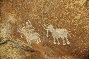
Some of the Bhimbetka rock shelters feature prehistoric cave paintings and the earliest are dated to 10,000 BCE, corresponding to the Indian Mesolithic.
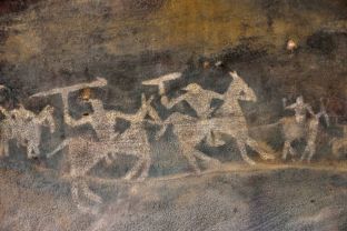
These cave paintings depict various types of animals and human figures with early evidence of community living with dance and hunting from the Stone Age. The paintings also depict warriors on horseback from a later time.
Link with Mythology
Indigenous people of Bhimbetka believes that Bhima during his exile used to rest here to interact with the locals. There is also a narrative that Bhima Worshiped Mata Vaishavi at this location and blessed for concurring the forthcoming war.
Auditorium cave.
The cave is one of the prominent features of Bhimbetka which throws light into the history of this place. It is surrounded by quartzite towers.
The cave’s plan is similar to a “right-angled cross” with four of its branches aligned to the four cardinal directions. The main entrance points to the east. At the end of this eastern passage, at the cave’s entrance, is a boulder with a near-vertical panel that is distinctive, one visible from distance and all directions – Chief’s Rock” or “King’s Rock]. The boulder with the Auditorium cave is the central feature of the Bhimbetka.
Cave paintings of Bhimbetka unravel the evolution of a civilization
The rock shelters and caves of Bhimbetka have a large number of paintings. Some of the oldest paintings are dated to 10,000 BCE.
It was W. Kincaid, a British India era official who first mentioned Bhimbetka in a scholarly paper in 1888.But the archeological significance of this rock caves was found by V. S. Wakankar. However, the prehistoric significance of Bhimbetka was revealed only in the 1970s.
There was human settlement here from the Stone Age through the late Acheulian to the late Mesolithic until the 2nd century BCE. The artefacts from the excavation site and the pigments present in deposits, as well as the rock paintings points to that.
The drawings and paintings of Bhimbetka can be classified under seven different periods.
V. S. Wakankar classified the drawings and paintings into seven different periods and dated the earliest paintings to have belonged to the upper Palaeolithic to be as early as 40,000 years ago
The colours used are vegetable colours which have endured through time because the drawings were generally made deep inside a niche or on inner walls.
Period I – (Upper Paleolithic): These are linear representations in green and include humans dancing and hunting.
Period II – (Mesolithic): small figures in this group show linear decorations on the body. There is animal as well as human figures and hunting scenes with the weapons such as barbed spears, pointed sticks, bows and arrows. The types of weapons used are clear indicators to the periods of history.
Tribal wars also have been portrayed here. The depiction of communal dances, birds, musical instruments, mothers and children, pregnant women, men carrying dead animals, drinking and burials are detected among the paintings.
Period III – (Chalcolithic) – These resemble paintings of the Mesolithic. These paintings denote that during this period the cave dwellers of this area were in contact with the agricultural communities of the Malwa plains, exchanging goods with them.
Period IV & V – (Early historic): The figures of this group have a schematic and decorative style and are painted mainly in red, white and yellow colors.
The association is of riders, depiction of religious symbols, tunic-like dresses and the existence of scripts of different periods.
The figures of yakshas, tree gods and magical sky chariots also have been found here.
Period VI & VII – (Medieval): These paintings are geometric linear and more schematic, however they show degeneration and crudeness in their artistic style. The colors used in these paintings seems to be prepared by combining black manganese oxides, red hematite and charcoal.
In one of the desolate rock shelters, the painting of a man holding a trident-like object and dancing has been found and it is assumed by many as Lord Shiva.
Many paintings of Bhimbetka has been lost or degenerated overtime.
It has been estimated that paintings of at least 100 rock shelters might have eroded away.
Bhimbetka stands with its numerous rock shelters in the lush green valley of Vindya ranges, since many centuries unravelling the history of mankind. It offers new lessons for exploring our roots taking a stroll through the depth of the caves which unfolds the untold history of people who thrived here centuries and decades ago.
How to reach Bhimbetka?
By air : Raja Bhoj Airport is the major airport of Bhopal, located around 15 km from the city center in Bairagarh suburban area on National Highway 12. Bhopal is well connected to the metros other cities by various companies’ airlines.
To reach Bhimbetka Rock Shelters from Bhopal, you can take a bus or taxi on NH46, which is about a 46 km drive.
By rail: The nearest railway station to the Bhimbetka Rock Shelters is Bhopal Junction (BPL]. It is served by the West Central Railways. Bhopal is on one of the two main Delhi to Mumbai railway lines and also on the main line to the southern state capitals of Chennai, Hyderabad, Bangalore and Thiruvananthpuram.
By road:
The nearest bus stand to the Bhimbetka Rock Shelters is Obaidullaganj, which is about 9 km away, and buses from Bhopal can take you there.
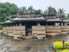
Kedaraswara temple in Balligavi , near Shikaripura in Shivamogga district of Karnataka is a Shiva temple built in trikuta style .It is a heritage site & protected monument under archeological survey of India [ASI]. The temple is presumed to be built during 11th century by the Hoysala kings who were feudatory of Western Chalukyan empire.
Location
Balligavi is a small town located in Shikaripura taluk, Shivamogga district, Karnataka, India.
It is an ancient Shiva temple where devotees from various parts of Karnataka and neighbouring states visit particularly during festivals like Shravana and Shivratri. The ancient Kedareswara temple is famous for its architectural significance and it is easily accessible from National highway.
The temple premises also include an artgallery with statues, paintings and sculptures of Hindu gods and goddesses from various centuries. Some of them are in dilapidated conditions.
Visiting Balligavi offers a delightful experience to devotees as well as individuals who are keen to understand the archeological significance of this heritage monument. Sri kedareswara temple is situated in Balligavi town at a picturesque place surrounded by lush green vegetation.
History
The town Balligavi is very ancient and it is mentioned in medieval inscriptions as Anadi rajadhani. Balligavi was a renowned town during the rule of western Chalukyas in 11th-12 th century. The golden age of Balligavi was during the rule of the Western Chalukya Empire during the 10th-12th centuries.
The ancient kedaraswara temple is built in distinctHoysala architectural style.
The temple has the cella [garbhagriha] with the Shivalinga [ universal symbol of Shiva ,the Hidu god].
During ancient times the temple was known as the centre of kalamukha sect of shaivism. The famous festivals celebrated in the temple are shravana and mahashivratri.
Kedareswara Temple architecture
The ancient kedareswara temple is built in trikuta style or having three shines with shikara facing east north and south. The temple shrines are capped by decorative towers of Hoysala style with kalasha on the top. According to the Mysore archaeological department , Kedareswara temple is the oldest example of the Western Chalukya- Hoysala architectural combinational style in Karnataka.
The western shrine has a vestibule and all the three shrines conjointly open to mahamandapa which is preceded by a sabhamandapa. The western shrine is presumed to be the oldest one. The western shrine is the oldest dating from the 7th or 8th century.
All shrines open up to a six-pillared hall called “mahamantapa” which is preceded by a large ornate open space called “sabhamantapa”.
The layout of the gathering hall or sabhamandapa is “staggered square” which has the effect of creating projections and recesses. Each projection of the wall has a complete “architectural articulation” (achieved by repetitive decoration). The gathering hall has entrances from the north, south and eastern directions.
The ceiling of the mantapa is flat and the inner ceiling is well carved with lotuses in them. The central ceiling has the carving of Tandaveshwara (dancing Shiva) with eight dikpalakas (guards).
The distinctive Hoysala crest symbol is evident in this temple also. The dome is a large sculpted piece known as helmet or amalaka. This is an excellent example of a trikuta “triple towers” temple in a transitional Western Chalukya-Hoysala architecture.
The superstructures over the shrines are 3-tiered (tritala arpita) vesara (combination of south and north Indian style) with the sculptural details being repeated in each tier.
Kedareswara temple has all the distinctive architectural styles of a Hoysala architectural monument. It includes the large decorative domed roof over the tower; the kalasha on top of it and the Hoysala crest (emblem of the Hoysala warrior stabbing a lion) over the sukhanasi (tower over the vestibule).
The dome is the largest sculptural piece in the temple with ground surface area of about 2×2 meters and is called the “helmet” or amalaka.
Its shape usually follows that of the shrine (square or star shape). The tower over the vestibules of the three shrines appear as low protrusions of the main tower .
The shrine interior :
The entrance to the shrine which faces east has a Nandi, the bull and a celestial attendant of Shiva.
The central shrine has a Shiv linga made from black marble .
The shrine to the south has a linga called Brahma and the shrine to the north has a statue of Janardhana (Vishnu).
The exterior architecture:
The exterior walls of temple are bult in “staggered-square” style with many projections and recesses which is a Hoysala design. The outer walls of the open mandapa (hall) have carvings of women wearing fine jewellery. Two Hoysala emblems were added in 1060 CE by king Vinayaditya.
The superstructure (tower) of the vimana is well- decorated with sculptures of Tandaveshwara, Varaha, Uma Narasimha, Bhairava etc. (avatars of Shiva and Vishnu) and the sukanasi of all three towers still exist.
How to reach Balligavi?
Nearest air ports
Hubbli airport is 130 km away.
Belgaum airport is 224km away from Balligavi town.
Nearest railway station
Shikaripura railway station is the nearest.
By road:
Bus services are available to Balligavi from nearby places like Shivamogga , Uduppi , Shikaripura etc.
From Shivamogga to Balligavi the distance is 74kms by bus or cab .
From Mangaluru to Uduppi buses or cabs are easily available and Uduppi to Shivamogga bus services reach Balligavi also.
[ Mangluru to Balligavi 234.2 kms]
References
A Concise History of Karnataka, pp 116-117, Dr. S.U. Kamath
Mahabalipuram is a famous heritage town listed under UNESCO world heritage sites and it is enriched with rock-cut cave temples, monolithic temples, bas-relief sculptures, and structural temples as well as the excavated remains of temples of Pallava architectural style.
Mahabalipuram (or Mamallapuram), located along southeastern India’s Coromandel Coast has a group of monuments built by the Pallava dynasty during 6th-9th centuries. The majestic edifices portray the dexterity of the Pallava craftsmen in carving temples and sculptures.
The site is well known for its 40 ancient monuments and Hindu temples, including one of the largest open-air rock reliefs in the world: the Descent of the Ganges or Arjuna’s Penance.
Other acclaimed Pallava monuments include Ratha temples with monolithic processional chariots, built between 630 and 668; mandapa viharas (cave temples) with narratives from the Mahabharata and Shaivite, Shakti or Shaaktha and Vaishnava inscriptions in a number of Indian languages and scripts; rock reliefs (particularly bas-reliefs); stone-cut temples built between 695 and 722.
This heritage site is restored after 1960 and now protected by the Archaeological Survey of India.
Location
The Mahabalipuram temples are located in the southeastern Indian state of Tamil Nadu, about 60 kilometres southwest of Chennai on the Coromandel Coast.
The origin of Mamallapuram- The city of Pallava dynasty
Mahabalipuram is also known by the name Mamallapuram; Mamalla means “Great Wrestler”, and refers to the 7th-century king of Pallava dynasty Narasimha Varman I.
The town is mentioned in history in various other names including Mamallapattana, Mavalipuram, Mavalivaram, Mavellipore, Mauvellipooram and Mahabalipur, all of which refer to a “great wrestler city” or “city of Mahabali”. Mabalipuram is also linked with the legend of is Mahabali, the demon king defeated by Vamana (an incarnation of Lord Vishnu).
Indian monuments and landforms are intricately linked with the vastness of its mythology and this sacred linking is not uncommon throughout the subcontinent. In the ancient monuments of Mahabalipuram the sculptures, cave temples and inscriptions are connected to history as well as mythology, particularly Mahabharata epic.
There is another story linking this heritage city with prosperity and growth as the Tamil word “mallal” means prosperity. It refers to the prosperity and economic growth of this city of Pallavas during 6th and 7th centuries.
It is curious to find that an 8th-century Tamil text by the early Bhakti movement poet Thirumangai Alvar, where Mamallapuram is called “Kadal Mallai” supporting this claim of Nagaswamy.
Most of the ancient texts , including seventh-century inscriptions refer this town of Palavas as “Mamallapuram” or its close variants. The name “Mahabalipuram” appears only after the 16th century as per records.
The town was also mentioned in colonial-era literature as “Seven Pagodas” by European sailors who landed on the coast and found the towers of seven Hindu temples built by Pallavas.
Marco Polo (1271-1295 CE) also has mentioned about “Seven Pagodas” and the name became associated with the shore temples of Mahabalipuram in publications by European merchants centuries later. However, currently Mahabalipuram monuments own fewer than seven towers, the name “ seven pagodas” has inspired speculation and debate.
In December 2004 Asian tsunami, generated by an earthquake in Indian ocean 160km away from Sumatra island as its epicentre [Indonesa] had a devastating impact on the shores of Tamilnadu also. In many places across the world, there was receding sea water exposing oceanic bed before the occurrence of towering tsunami wave. The tsunami had briefly exposed the beachfront near Saluvankuppam (now north of Mahabalipuram), revealing inscriptions and structures. According to a BBC report that these inscriptions dated back to 9th century and they might have been destroyed later by a 13th-century tsunami.
The tsunami also revealed large structures on the seabed about a kilometre offshore. About this site archaeologists opined that it might be the ancient Mahabalipuram. According to a Science article, the tsunami exposed rocks with elaborately sculpted head of an elephant and a horse in flight. Other artefacts exposed were a small niche with a statue of a deity, another rock with a reclining lion, and other Hindu religious iconography.
In Mahabalipuram group monuments Shore temple is prominent ancient monument close to the beach area. Marine archaeologists and underwater diving teams have explored a site east of the Shore Temple after the 2004 tsunami. This has revealed ruins of fallen walls, a large number of rectangular blocks and other structures parallel to the shore, and the forty surviving monuments.
Pallava rule & emergence of Mamallapuram
Mamallapuram became prominent during the Pallava-era reign of Simhavishnu during the late 6th century. During his reign there was great friction with Pandyas and Cheras.
The monuments of Mahabalipuram are a fusion of religion, culture and legend relating to the Hindu religious pantheon. The monuments depict many 7th- and 8th-century Sanskrit inscriptions and also unravel the medieval South Indian history, culture, reign and religion.
Mamallapuram’s architecture is linked to Simhavishnu’s son, Mahendravarman I (600-630 CE), who was a patron of the arts. Mahendravarman’s son, Narsimha Varman I, continued the work of this city architecture . After a brief hiatus, temple and monument construction was revived during the reign of Rajasimha (or Narasimhavarman II; 690–728).
The site has about forty monuments, including monolithic temples, cave temples , sculptures ,rock reliefs etc.
Types of monuments in Mahabalipuram
Rathas: chariot-shaped temples
Mandapas: Cave temples
Rock reliefs
Structural temples
Excavations
There are ten major rathas, ten mandapas, two rock bas-reliefs and three structural temples.
The monuments portray Hindu mythology gods and goddesses. The reliefs, sculptures and architecture incorporate Shaivism, Vaishnavism and Shaktism.
Ratha temples
The ratha temples are carved in the shape of chariots in blocks of diorite and granite in sand, carving legends in stone.
They include five monolithic structures projecting above the beach, known as the Five Rathas or the Pandava Rathas.
They are temples with chariot carvings dedicated to deities and concepts of the Shaivi, (Shiva), Vaishnavi (Vishnu) and Shakti (Durga) traditions of Hinduism. These temples are dated to the 7th century.
Cave temples
Mandapas also refer to rock-cut cave temples or shrines, built according to the same concept, and Mamallapuram has many mandapas dated to the 7th and 8th centuries. Cave temples of Mahabalipuram have three entrances
Trimurti cave in northern Mamallapuram
Temple entrance with lingam
Shiva shrine
Temple entrance, with bas-reliefs on interior wall
Vishnu shrine
Mandapa is a Sanskrit term for a typically square vestibule, pillared hall or pavilion.
It was a space for gathering for rituals for the people. Cells or sanctums would often be included, creating a vihara.
The noteworthy feature of cave temples is that they are in incomplete form, and therefore provides much information about how cave monuments were excavated and built in 7th-century. The process of producing rock-cut cave temples influenced later structural Hindu temples.
Segments of the caves indicate that artisans worked with architects to mark off the colonnade, cutting deep grooves into the rock to create rough-hewn protuberances with margins. The hanging rocks were then cut off, and they repeated the process. After the excavation, other artisans moved in to polish the rocks and begin the creation of designs, motifs, friezes and Hindu iconography.
Varaha cave temple
The Varaha cave was excavated from a vertical wall on the west face of the main Mamallapuram hill. it is known for its four sculptures depicting Hindu legends: the Vamana-Trivikrama legend, the Varaha legend, the Durga legend and the Gajalakshmi legend and dated back to the 7th century.
Kotikal cave temple
It is a simple, early excavation with two pilasters on its facade. Inside the Kotikal cave temple are an oblong ardha-mandapa (half or partial hall) and a square sanctum (garbha griya). The front of the sanctum has mouldings and features similar to a free-standing temple. The sanctum door is flanked by female dvarapalas (sculptures guarding the door) on each side.
The female guardians on the sanctum door suggest that the deity in the sanctum was probably Durga, the Hindu goddess.
One pillar has an inscription in the Grantha alphabet which transliterates as “Sri Vamankusa”. It is believed that the temple was built by a patron (according to Ramaswami, possibly Telugu). The temple dates back to the early Mahendra period.
Dharmaraja cave temple
The Dharmaraja cave temple, also known as the Atyantakama cave temple, is on the south side of Mamallapuram hill near the Mahishamardini cave.
The temple has a fourteen-line Sanskrit inscription in the Grantha alphabet with an epithet. The cave is probably built during the reign of King Rajasimha (late 7th or early 8th century), but other archeologists date it to the 7th-century King Paramesvara-varman .A few other scholars assign it to the Mahendra period, based on its style.
Ramanuja cave temple
One of the most sophisticated and complete cave temples, excavated in the center of the main Mamallapuram hill, on its eastern scarp.
The Ramanuja cave consists of a rectangular ardha-mandapa, marked with a row of pillars. At the side of its facade are two model vimanas with a square rock platform. On the floor between the two pillars of the facade is a Sanskrit inscription in the Grantha alphabet praising Rudra, evidence that the temple was originally associated with Shaivism. The inscription’s florid font and epithets date it to the 7th century and Parameshvara Varman.
The temple was partially renovated centuries after its construction into a shrine for the Vaishnava scholar, Ramanuja. The later artisans added the six crudely-cut, free-standing pillars in front, probably to extend the mandapa.
Koneri mandapa
The Koneri temple is dedicated to Shiva and it is carved into the western side of the main hill in Mamallapuram. The temple has two rows of four pillars and two pilasters. The front row is considerably simpler than the row near the shrines, which is intricately carved.
Krishna mandapa
The Krishna mandapa is a sophisticated cave, built in 7th century, with large panels depicting Hindu mythology and the culture, situated near the Descent of the Ganges bas-relief. The walls of the pillared hall depict village life woven into the story of Krishna. Krishna holds Goverdhana Mountain, under which are people, cattle and other animals, in one section.
Atiranachanda cave temple
This 7th-century built cave temple is in the village of Saluvankuppam, north of Mamallapuram. It has a small facade, with two octagonal pillars with square sadurams (bases) and two four-sided pilasters. Behind the facade is an ardha-mandapa and a small, square sanctum. In front of the facade are empty mortise holes, probably later additions to a now-missing mandapa.
The sanctum entrance has two Shaiva dvarapalas. Inside is a later black, polished, 16-sided, tantra-style Shiva linga.
Adivaraha cave temple
The Adivaraha cave temple is built in 7th century and it is also known as the Maha Varaha Vishnu temple. It is known for sculptures relating the Hindu legends about Varaha (Vaishnavism), Durga (Shaktism), Gangadhara (Shaivism), Harihara (Vaishnavism-Shaivism fusion) and Gajalakshmi (Vaishnavism).
The temple is at the northern end of the main Mamallapuram hill, on its western side.
This temple is opened only during times of pooja in the morning and evening.
The temple is dedicated to Varaha incarnation of god Vishnu. In the panel inside temple Shiva is represented as Ganga dhara which is a Pallava style of temple architecture.
Mahishasuramardini cave temple
The Mahishasuramardini cave, also known as the Mahishamardini mandapa, is found at the southern end of the site (known locally as Yamapuri). Excavated on the eastern scarp of a boulder on the main Mamallapuram hill, above it are the ruins of the Olakkannesvara temple. According to Ramaswami, the temple is unfinished but what has been carved represents the ultimate in Tamil temple rock art. The cave has many panels, and their narrative follows the Markandeya Purana.
Panchapandava mandapam
Just south of the Arjuna’s Penance bas-relief is the Panchapandava mandapam, the largest (unfinished) cave temple excavated in Mamallapuram.
It has six pillars, one of which has been restored, and two pilasters as its facade. Another row of pillars follows in the ardhamandapa, and largely-unfinished, deep side halls also contain pillars. Evidence of work in progress suggests that the cave was intended to have a walking path and large wall reliefs.
Other mandapas
The Mamallapuram site includes a number of other unfinished cave temples. Among them are the Trimurti temple, dedicated to Brahma, Shiva and Vishnu.
Pulipudar and adjacent cave temples near the Konerippallam tank and the Tiger Cave, also known as the Yali mandapa, dedicated to Lakshmi (the goddess of prosperity.
Structural temples
The structural (free-standing) temples at Mamallapuram have been built with cut stones as building blocks, rather than carved into a rock (cave temples) or out of a rock (ratha temples).
They represent a different stage, style and sophistication than the other monuments, are some of best examples of early medieval Tamil Hindu-temple architecture These temples are dedicated to Shiva, Vishnu and Durga, although more Shiva iconography has survived over time.
Shore Temple of Mahabalipuram
The Shore Temple complex is near the Mamallapuram shore. It consists of a large temple, two smaller temples and many minor shrines, open halls, gateways, and other elements, much of which is buried by sand.
The main temple is within a two-tier, compound wall with statues of Shiva’s vahana (vehicle), Nandi, surrounding it. The 60-foot (18 m)-high temple has a 50-square-foot (4.6 m2) plan. It is a stepped pyramidal tower, arranged in five tiers with Shiva iconography.
The temple includes a path around its main sanctum and a large, barrel vaulted roof above its doorway. Pilasters on the outer wall divide it into bays.
A small temple in the original forecourt of the larger temple. The other two temples in the complex are behind the main temple, face each other and are known as the Rajasimhesvara (or Nripatisimha Pallava Vishnugriha) and the Kshatriyasimhesvara.
The main shrine has Vishnu and Durga images. The rear temple walls are carved with Somaskanda bas-relief panels depicting Shiva, Parvati and the infant Skanda.
Most of its Nandi sculptures were in ruins and scattered around the main temple complex. Twentieth-century restoration efforts replaced them in accordance with the inscriptions, descriptions of the temple in medieval texts and excavations of layers which confirmed that Nandi bulls were seated along its periphery.
The Shiva temples of the complex have been dated to the early 8th century and are attributed to the reign of the Pallava king Rajasimha (700-728). The Vishnu temple, with an image of a reclining Vishnu discovered after excavations, has been dated to the 7th century.
Olakkanesvara temple
The Olakkanesvara temple is situated on the rock above the Mahishamardini cave temple. It is also known as the Old Lighthouse because of its conversion by British officials. The temple is built by King Rajasimha ,in the early 8th century from grey granite cut into blocks.
This temple is in dilapidated condition and its superstructure is missing; what remains is a square building with its west entrance flanked by dvarapalas. The walls of the temple depict the Ravananugraha legend from the Ramayana and a relief of Dakshinamurti (Shiva as a yoga teacher). Its name is modern, based on the “ollock of oil” per day which was burnt by local residents to keep the temple flame lit.
Mukundanayanar temple
The Mukundanayanar temple has ratha-like architecture. North of the main hill in Mamallapuram, it has been dated to the early 8th century and attributed to King Rajasimha.
Rock reliefs
Reliefs are carved on rocks or boulders. These include the wall of the Krishna mandapa, where a superstructure was added in front of the relief.
The best-known rock relief in Mahablipuram is the Descent of the Ganges (also known as Arjuna’s Penance or Bhagiratha’s Penance), the largest open-air rock relief.
The Descent of the Ganges is considered one of the largest bas-relief works in the world. The relief, consisting of Hindu mythology, is carved on two 27-metre-long (89 ft), 9-metre-high (30 ft) boulders.
Inscriptions near the panel with the light house in the background
There are two primary interpretations regarding this descent of ganges.
The first one is the effort needed to bring the Ganges from the heavens to earth, and the Kiratarjuniya legend and the chapter from the Mahabharata about Arjuna’s efforts to gain the weapon he needed to help good triumph over evil. A portion of the panel shows the help he received from Shiva to defeat the Asuras. Included in the panel are Vishnu, Shiva, other gods and goddesses, sages, human beings, animals, reptiles and birds.
According to another interpretation, an ascetic Bhagiratha is praying for the Ganges to be brought to earth. Shiva receives the river, to which all life is racing in peace and thirst. This myth has not been universally accepted as central characters are missing or are inconsistent with their legends. The absence of a boar from the entire panel makes it doubtful that it is single story.
However, scenes of Arjuna’s penance and the descent of the Ganges are affirmed.
The granite reliefs, from the early or middle 7th century, are considered by The Hindu as “one of the marvels of the sculptural art of India.
Group of Monuments at Hampi, is a UNESCO World Heritage Site located in the town of Hampi in Vijayanagara district, east-central Karnataka, India. Hampi is one of the most sought-after heritage tourism destinations in India, renowned for its architectural and archeological significance.
A glimpse into the lost glory of Hampi
Hampi group of monuments include Hindu, Buddhist and Jainist temples depicting a mélange of tradition and culture. This ancient heritage city was the capital of the Vijayanagara Empire which ruled this part of Karnataka from 1336 to 1565.Later it faded into oblivion with Muslim invasion of the empire.
This ancient city of glorified Vijayanagra empire remained in total neglect until the mid-19th century, when Alexander Greenlaw visited here and photographed the site in 1856. However, these photographs remained hidden from public domain for decades in the United Kingdom, till it published in 1982. Greenlow had created an archive of 60 calotype photographs of temples and royal structures of that period which unravel the great historical and cultural significance and the most invaluable source of evidence of the mid-19th-century Hampi.
Location
The present day Hampi is a small modern town with the city of Hosapete only13 kilometres (8.1 miles) away from it , in Karnataka state, India. It is situated on the banks of the Tungabhadra River in the eastern part of central Karnataka.
It is situated 140 kilometres southeast of the world famous Badami and Aihole archaeological sites of Karnataka.
The ruins of a sleeping empire -Vijayanagara
Hampi with its innumerable relics and artefacts unfolds the story of dynasties ruled over this region for centuries. Hampi was the capital of the Vijayanagara Empire which ruled this part of Karnataka from 1336 to 1565. Later Vijayanagara Empire was vanguished by a coalition of Muslim sultanates in 1565, and post that Hampi faded into oblivion for several decades.
This ancient heritage town with its majestic relics are spread over 4,100 hectares. UNESCO has described this heritage town as an “austere, grandiose site” of more than 1,600 surviving remains of the last great Hindu kingdom in South India.
Hampi group of monuments includes forts, riverside features, royal and sacred complexes, temples, shrines, pillared halls, mandapas, memorial structures, water structures etc.
Hampi- the centre of overseas trade:
Hampi was a major centre of trade at the time of Vijayanagar Empire, attracting traders from Persia and Portugal mostly. Foreign traders found it as a safe haeven to trade and become immensely wealthy. During 1500 CE Hampi was the world’s second-largest medieval-era city after Beijing. It was one of the wealthiest cities of Indian subcontinent which fascinated many 16th-century traders from across the Deccan area, Persia and the Portuguese colony of Goa.
Hampi – the cradle of arts and infrastructure development
The Vijayanagara rulers fostered developments and they were also lovers of various art forms. The dynasty focused on developing roads, waterworks, agriculture, religious buildings and public infrastructure. According to the accounts of UNESCO, Vijayanagara empire had many forts, riverside features, royal and sacred complexes, temples, shrines, pillared halls, mandapas (halls for people to sit), memorial structures, gateways, check posts, stables, water structures, and more . Being a mighty empire Vijayanagara maintained a strong military and fought many wars with sultanates to its north and east.
The centuries old city was multi-religious and multi-ethnic; Still the ruins and vestiges show Hindu and Jain monuments next to each other.
The buildings predominantly followed South Indian Hindu arts and architecture dating to the Aihole-Pattadakal styles, but the Hampi builders also used elements of Indian architecture in the Lotus Mahal, the public bath and the elephant stables.
The monuments at this site probably might have been built in colours rather than the sandstone tint visible in the current era.
global sinificance of Hampi through texts& scripts
The V ijayanagra empire has been mentioned in many foreign texts and documents and it adds to the global significance of Hampi.
Robert Sewell published his scholarly treatise A Forgotten Empire in 1900, which brought into light the ancient glory of this empire of Vijayanagra dynasty.
Alexander Rea, an officer of the Archaeological Survey department of the Madras Presidency within British India, published his survey of the site in 1885.
The growing interest led Rea and his successor Longhurst to clear and repair the Hampi group of monuments.
According to the Hoysala-period inscriptions Hampi was known by alternate names such as Virupakshapattana, Vijaya Virupakshapura in honour of the old Virupaksha (Shiva) temple there.
The site is significant historically and archaeologically, for the Vijayanagara period and the previous period of sleeping history. The Archaeological Survey of India continues to conduct excavations in the area to unravel the mysterious past of this wonderful town.
Sacred links of myth surrounding the name’ Hampi‘
According to Sthala Purana, Parvati (Pampa) pursued her ascetic, yogini lifestyle on Hemakuta Hill, now a part of Hampi, to win and bring ascetic Shiva back into householder life. Shiva is also called Pampapati as the husband of pampa or goddess Parvati. The river near the Hemakuta Hill came to be known as Pampa river. As in many other parts of Indiian subcontinent here also the sacred linking of geographical regions is evident. The Sanskrit word Pampa morphed into the Kannada word Hampa and the place Parvati pursued Shiva came to be known as Hampe or Hampi.
Rising up of Vijayanagara empire from the ashes of pampapura
The heritage town has several less known historical and mythological stories connected to the entire subcontinent. The excavations in Hampi connects it with Maurya empire .Emperor Ashoka , the great Mauryan ruler is closely linked with Hampi according to Rock Edicts in Nittur and Udegola [ in Bellary district ]269-232 BCE. The rock engravings suggest that this region was part of the Maurya Empire during the 3rd century BCE. A Brahmi inscription and a terracotta seal dating to about the 2nd century CE also have been found during site excavations to corroborate the facts.
The town Hampi is mentioned in Badami Chalukya’s inscriptions as Pampapura, dating from between the 6th and 8th centuries. By the 10th century, pamapapura had become a centre of religious and educational activities under the reign of Chalukya empire. Kalyana Chalukyas ruled this area and the inscriptions of the century state that the kings made land grants to the Virupaksha temple.
Several inscriptions from the 11th to 13th centuries are about the Hampi site, with a mention of gifts to goddess Hampa-devi. Between the 12th and 14th centuries, Hindu kings of theHoysala Empire of South India built temples to Durga, Hampadevi and Shiva, according to an inscription dated about 1,199 CE. Hampi became the second royal residence; one of the Hoysala kings was known as Hampeya-Odeya or “lord of Hampi”.The Hoysala Empire and its capital Dvarasamudra in southern Karnataka was plundered and destroyed in the early 14th century by the armies of Alauddin Khalji.
The Kampili kingdom in north-central Karnataka followed the collapse of Hoysala Empire. The Kampili kingdom ended after an invasion by the Muslim armies of Muhammad bin Tughlaq. In 14th century Muslim rulers of the Delhi Sultanate, Alauddin Khalji and Muhammad bin Tughlaq, invaded and plundered South India.
In 1326 CE the army of Muhammad bin Tughlaq destroyed the kingdom mercilessly.The Hindu women of Kampili committed jauhar (ritual mass suicide) when the Kampili soldiers faced defeat by Tughlaq’s army.
In 1336 CE, the Vijayanagara Empire arose from the ruins of the Kampili kingdom. It grew into one of the famed Hindu empires of South India that ruled for over 200 years.The Vijayanagara Empire built its capital around Hampi, calling it Vijayanagara.
Historians suggests that Harihara I and Bukka I, the founders of the empire, were commanders in the army of the Hoysala Empire stationed in the Tungabhadra region to ward off Muslim invasions from the Northern India. Another story proposed is that these people were Telugu people, who took control of the northern parts of the Hoysala Empire during its decline. As per texts such as Vidyaranya Kalajana, Vidyaranya Vritanta, Rajakalanirnaya, Pitamahasamhita, Sivatatvaratnakara, they were treasury officers of Pratap Rudra, the King of Kakatiya Kingdom.
The origin of Viaya nagara empire stems from the story of invasion by Muhammad Bin Tughlaq who came looking for Baha-Ud-Din Gurshasp (who was taking refuge in the court of Pratap Rudra). In that battle Pratap Rudra was overthrown and Kakatiya was vanguished. It was during this period of time the two brothers Harihara I and Bukka I, with a small army came to the present site of Vijayanagara, Hampi.It was a crucial moment in history when Vidyaranya, the 12th Jagadguru of Sringeri took them under his protection and established them on the throne and the city was called Vidyanagara in A.D. 1336.Later from here vijayanagra emerged as a far-flung empire.
Decline of vijayanagaraempire
In 1565, at the Battle of Talikota, a coalition of Muslim sultanates attacked the Vijayanagara Empire. They captured and beheaded the king Aliya Rama Raya, followed by a massive destruction of the infrastructure fabric of Hampi and the metropolitan Vijayanagara. The city was pillaged, plundered and burnt for six months after the war, then abandoned as ruins, which are now called the Group of Monuments at Hampi. Perhaps the burnt dilapidated Hampi is yet another example for the inglorious and ignominious religious fanaticism of Muslim rulers who destroyed Indian cultural history into ashes.
Majestic monuments of Hampi
Most of the monuments of Hampi were built between 1336 and 1570 CE during the reign of Vijayanagara empire. The site has about 1,600 monuments and covers 41.5 square kilometres .
The Hampi site has been studied by hisorians in three broad zones such as :
sacred centre
urban core or the royal centre
metropolitan Vijayanagara.
The sacred centre, alongside the river, contains the oldest temples with a history of pilgrimage and monuments pre-dating the Vijayanagara empire.
The urban core and royal centre have over sixty ruined temples beyond those in the sacred centre, but the temples in the urban core are all dated to the Vijayanagara empire. The urban core also includes public utility infrastructure such as roads, an aqueduct, water tanks, mandapa, gateways and markets, monasteries. This distinction has been assisted by some seventy-seven stone inscriptions.
Most of the monuments of Hampi are depicting Hindu temple architecture and the public infrastructure such as tanks and markets include reliefs and artwork depicting Hindu deities and themes from Hindu texts.
There are also six Jain temples and monuments and a Muslim mosque and tomb in Hampi.
The architectural style of monuments of Hampi is Dravidian, rooted in Hindu arts and architecture of [the second half of the 1st millennium] the Deccan region. It also included elements of the arts that developed during the Hoysala rule of the empire between the 11th and 14th century such as in the pillars of Ramachandra temple and ceilings of some of the Virupaksha temple complex.
Major temple monuments of Hampi
Virupaksha temple complex
The Virupaksha temple is the oldest Hindu shrine, the main destination for pilgrims and tourists. It includes parts of the Shiva, Pampa and Durga temples existed in the 11th-century; it was extended during the Vijayanagara era. The temple is a collection of smaller temples.
According to local tradition, the Virupaksha is the only Hindu temple that continued to be a gathering place of Hindus and visited by pilgrims after the destruction of Hampi in 1565. The temple attracts large crowd during the annual festivals, with a chariot procession to mark the marriage of Virupaksha and Pampa [ Shiva &Parvati] is held in spring, as is the solemn festival of Maha Shivaratri.
Krishna temple
This temple is also called Balakrishna temple, situated on the other side of Hemakuta hill, is about 1 kilometre south of Virupaksha temple. It is dated back to 1515 CE.
The temple faces to the east; it has a gateway with reliefs of all ten avatars of Vishnu starting with Matsya at the bottom. Inside the ruined temple for Krishna ruined shrines for goddesses are also found.
South of the Krishna temple’s exterior are two adjacent shrines, one containing the largest monolithic Shiva Linga and the other with the largest monolithic Yoga-Narasimha avatar of Vishnu in Hampi.
Achyutaraya temple
The Achyutaraya temple, also called the Tiruvengalanatha temple, is about 1 kilometre east of Virupaksha temple and close to Tungabhadra River. It is referred to be in Achyutapura in inscriptions and is dated to 1534 CE. It is one of the four largest complexes in Hampi.
Vitthala temple
It is over 3 kilometres (1.9 miles) north-east of the Virupaksha temple near the banks of the Tungabhadra River. It is an artistically sophisticated Hindu temple in Hampi, and is part of the sacred centre of Vijayanagara.
Hemakuta hill temples & inscriptions
The Hemakuta hill lies between the Virupaksha temple complex to the north and the Krishna temple to the south. It has monuments that are preserved examples of pre-Vijayanagara and early-Vijayanagara temples and constructions.
The site has several important inscriptions. The hill has more than thirty small-to-moderate-sized temples, together with water cisterns, gateways, and secular pavilions.
The Hazara Rama temple
This temple is also referred to as the Ramachandra temple in inscriptions, occupied the western part of the urban core in the royal centre section of Hampi. This temple was dedicated to Rama of the Ramayana.The inner walls of the temple has friezes containing extensive narration of the Hindu epic Ramayana
Kodandarama temple and riverside monuments
The Kodandarama temple complex lies near the Tungabhadra River, and is north of Achyutaraya temple. The temple overlooks Chakratirtha, where the Tungabhadra turns northwards towards the Himalayas. The river banks has a Vijayanagara-era ghat and mandapa facilities for bathing. There is a dipa stambha (lighting pillar) in front of the temple under a Pipal tree, and inside the temple there is a sanctum dedicated to Rama, Sita, Lakshmana and Hanuman.
Pattabhirama temple complex
This temple complex is in the southern suburban centre outside the sacred centre and the urban core, about 500 metres from the ASI Hampi museum. It seems to be built in the early 16th century and dedicated to Rama of Ramayana[ Incarnation of Lord Vishnu].It was at the nucleus of economic and cultural activity of this suburb, now located north-east of Kamalapura. The complex, also known as Varadevi Ammana Pattana.
Mahanavami platform
This monument, is within a 7.5-hectare (19-acre) enclosure at one of the highest points inside the royal centre (urban core). It is mentioned in the memoirs of foreigners who visited Vijayanagara and is referred as “House of Victory”.
The largest monument in this complex has three ascending square stages leading to a large, square platform that likely had a wooden mandapa above it. This was burnt down during the destruction of Hampi.
It has reliefs—possibly a catalogue of 14th-century royal activities—and lines of marching animals including elephants, horses and camels.
Reliefs on the south side show musicians and dancers, including female stick-dancers. The third level reliefs show a battle procession, couples and scenes of common citizens celebrating Holi (Vasantotsava) by throwing water at each other.
The Square Water Pavilion, also called the Queen’s Bath, is in the south-east of the royal centre. It has a pavilion, a water basin and a method of moving fresh water to it and taking away wash water and overflows. The basin is enclosed within an ornate, pillared, vaulted bay. The building’s interior arches show influence from Indo-Islamic architecture, reflecting an era in which Hindu and Muslim arts influenced each other in India
The Hampi monuments include aqueducts to carry water to tanks and other parts of the city, as well as drains and channels to remove water overflow.
Several major temples in Hampi have an embedded kitchen and 100-or-more-pillared feeding halls.
Hampi also had a dedicated public Bhojana shala (house of food) where numerous thali (dish) were carved in series in a rock on both sides of a water channel.
Lotus mahal
The Lotus Mahal is a two-storeyed pavilion in the royal centre. The Lotus Mahal combines a symmetrical, square, Hindu mandala design with lobed arches, vaults, and domes of the Indo-Islamic style. Its basement and pyramidal towers are based on Hindu temple architecture.
Like almost all of the structures in Hampi’s royal centre, this monument has no inscriptions nor epigraphs mentioning its origin.
The Lotus Mahal and other structures in the Hampi urban core, however, were not built with Muslim patronage.
These buildings reflect the assimilative approach of the Vijayanagara Hindu rulers. Lotus Mahal looks like a syncretic, congested space and its purpose is unclear. Speculations include it being a council hall.
Hindu temple vestiges in Hampi
The Hampi site has more than 1,600 surviving ruins mostly of Hindu temples spread over a wide area.
Significant monuments include a temple near the octagonal bath for Saraswati, a Hindu goddess of knowledge and music.
temple in the suburbs for Ananthasayana Vishnu.
an Uddana Virbhadra temple for Shiva and Vishnu
a shrine for Kali, the fierce form of Durga unusually shown holding a ball of rice and a ladle (Annapurna).
an underground temple in the royal centre; a Sugriva cave temple.
the Matanga hill monuments; the Purandaradasa temple dedicated to the scholar-musician famed for the Carnatic music tradition.
the Chandrashekhara temple for Shiva near the Queen’s bath monument
the Malyavanta hill dedicated to Rama-Sita-Lakshmana and Shiva. The Malyavanta hill features several shrines including the Raghunatha temple and a row of Shiva lingas carved in stone.
Jain monuments at Hampi
Reliefs of Jain temples at Hampi include Hemkut Jain temples, Ratnantraykut, Parsvanath Charan and Ganagitti Jain temples. Most of the idols are now missing from these temples, which were built in the 14th century.
Ganagitti temple complex
Hampi monuments attract millions of tourists every year to Karnataka from various parts of the globe. The monuments tell the story of many dynasties and the multi ethnic societies lived in this land. It stands as an integral part of the history of Indian subcontinent which tells numerous tales of conquests, expansion and widening of frontiers by various Northern dynasties and invasion by foreign Muslim rulers.
The Indo-Islamic style is visible in a few monuments, such as the Queen’s bath and Elephant stables. UNESCO has commented that it reflects a highly evolved multi-religious and multi-ethnic society.
The Ganigitti Jain temple is near Bhima’s gate in the south-east of the urban core section of Hampi. In front of it is a monolithic lamp pillar. The temple faced north; it is dated to 1385 CE, during the rule of Hindu king Harihara II, based on an inscription in the temple. It is dedicated to Tirthankara Kunthunatha and has plain walls, a pillared mandapa and a square sanctum from which the Jina’s statue is missing.
A cluster of Jain 150 meters east of the elephant stables. One north-facing temple is dedicated to Parshvanatha Tirthankara. It was built by King Devaraya II and dates to 1426 CE, per an inscription in the temple. In front of the temple are two ruined temples
Muslim monument at Hampi
The Hampi site includes a Muslim quarter with Islamic tombs, two mosques and a cemetery. These are neither in the sacred centre nor in the royal centre of the Hampi site.
There is a Muslim monument in the south-east of the urban core on the road from Kamalapura to Anegondi, before Turuttu canal in the irrigated valley. This monument was first built in 1439 by Ahmad Khan, a Muslim officer in the army of Hindu king Devaraya II. The monuments include a mosque, an octagonal well, and a tomb. The mosque lacks a dome and is a pillared pavilion, while the tomb has a dome and arches.
How to reach Hampi ?
The nearest airport to Hampi, Bellary is 60 km away from Hampi.
Hubli Airport is another Airport which is 143 km away from Hampi.
Also, JSW Vidyanagar Airport in Toranagallu is located approximately 40 kms from Hampi.
However, if you are a foreigner visiting the places you need to step down at Bengaluru Airport to get Visa on Arrival. You can book domestic flight tickets from Bengaluru to Bellary or Hubli to reach Hampi without any delay.
By road :
To reach Hampi you can choose buses or cabs.
Bangalore to Hampi 343 km 6 hours 2 mins
Many buses are available to Hosapete town, Hospet has great road connectivity from Bangalore[ state- Karnataka] and Mumbai,Pune&Kolhapur[ state-Maharashtra].
By train:
People from other states of India may reach Hampi by booking tickets to Hosapete Junction (Hospet) railway station (railway station code: HPT).
Praveswara temple, Thalagunda in Karnataka is an ancient shiva temple of Kadamba dynasty , a monument protected monument by Archeological Survey of India[ASI] due to its historical significance.
Thalagunda,karnataka
Thalagunda is a village in the Shikaripura taluk of Shivamogga district in the state of Karnataka, India. The village has been referred as Sthala-Kundura, Sthana-Kundur and Sthana-kunja-pura during ancient period. This hamlet is situated about 45 km from Banavasi, 20 km from Soraba and 7 km from Siralkoppa town.
There are many ancient temples in Thalagunda village including pranaveshvara, gangaadhareshvara, trineetra and veerabhadra temples. Praveswara temple is a protected monument by Archeological Survey of India[ASI] due to its historical significance.
According to the inscription found in the pillar of pranaveswara temple, it can be assumed that the temple was worshiped by earlier rulers including the Satakarnis. The temple dates back to the Satavahana period. However the current findings of architecture denotes that it is not of the Satavahana period but of the early Kadambas although explorations around the temple premises had revealed brick structure of the Satavahana period.
Pranaveswara temple
The temple is a small square building consisting of a garbhagriha and a sukanasi. There is a huge Shivalinga inside the sanctum. The garbha-griha doorway jambs are carved out of Kadamba inscription stones, the entrance doorway construction style denotes that it is of a later period, perhaps of the eleventh century CE.
Thalagunda inscription pillar
The Talagunda pillar inscription of Kakusthavarman is a well known epigraphic record in Sanskrit found in the ruined pranaveswara temple. The pillar is located in front of the Pranavalingeshwara temple.
The inscriptions are engraved on hard grey granite and dated to between 455 and 470 CE. It throws light into the history of Kadamba dynasty and the reign of king Śāntivarma in northwest Karnataka.
The pillar is 1.635 metres (5.36 ft) high with a 0.4 metres (1.3 ft) square top. It is octagonal shaft that slightly tapers and narrows as it goes up. The width of the octagonal face is 0.178 metres (0.58 ft). The inscription is found on all faces, but on 7 of the 8 faces, it consists of two vertical lines that start at the bottom of the pillar. On the eighth face, we can find just one short line.
The inscription consists of 34 poetic verses that respect the chanda rules of Sanskrit. It is the earliest epigraphical evidence found in Karnataka about the existence of a Hindu temple dedicated to Shiva in Talagunda, the construction of a temple water tank, and the practice of worshipping the Shiva Linga before about 450 CE.
The inscription unravels the glory of Kanchipuram as a center (ghatika) for advanced studies in ancient India, where the already learned Brahmin Mayurasarman from Talagunda goes with his counsellor to study the whole Veda. It also throws light into the cultural values and customs prevailed in the 5th-century India with the mention of “music” and goddess of wealth (Lakshmi) and speaks about the practice of marriage between north Indian and South Indian empires.
How to reach Thalagunda ?
The nearest railway station is Shivamoga .You may reach Manglore or Bangluru by flight and may reach Shivamoga by train or bus service. Approximately a one and half hour journey from Shivamoga by cab may help you reach Thalagunda[77.5km].
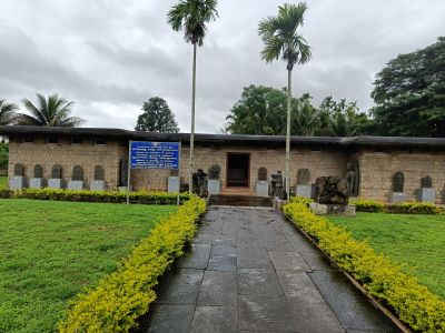
Balligavi art gallery is situated close to Kedareswara temple in Balligavi , Shimoga district, which is a pilgrim centre where main deity is Mahadev or Shiva .
Balligavi , is a town in Shikaripura taluk of Shivmoga district. Its an ancient town with various names such as Baligrama, Dakshina Kedara, Valliggame and is well -known for ancient sculptures and idols.
Balligavi was an important city during the 11th – 12th century Western Chalukya rule. The term Anadi Rajadhani (ancient capital) used in medieval inscriptions to describe this town
Archeologically Balligavi dates back to Satavahana -Kadamba era of ancient history[4th- 5 th century A.D. The earliest inscription mentioning the name Balligavi is a 685 CE BadamiChalukya inscription.
Myth
It is believed that Pandavas of Mahabharatha [epic] visited Balligavi during their vanavasa [ forest sojourn] period and installed shiva linga ,more precisely panchalinga and the seity of the temple later established here is known by the name panchalingeswara.
kedareswara temple of Balligavi is a hoysala chalukya architectural temple which includes the art gallery in its premises .
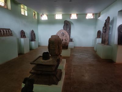
The art gallery displays very ancient idols and sculptures which are the vestiges of the bygone era. Many of these sculptures are broken.
The gallery also has numerous paintings which delineate the history of Sreekedareswara temple.
Balligavi art gallery
The art gallery displays idols & sculptures of ancient era . The sculptures describes the Hindu god shiva ,Ganapathi, devi parvathi or Durga. Kedareswara temple is a pilgrim centre where main deity is Mahadev or Shiva . The archeological gallery is located within the temple premises on the left side.
The Balligavi art gallery and temple is protected by Archeological survey of India. Sculptures and idols are displayed as two sections inside and outside the art gallery.
Paintings of ancient Kedareswara temple & many huge sculptures are found inside the art gallery building .
Numerous ganapathi , devi durga idols in stone are placed outside the art gallery building in an ancient Mandapa like structure which seems to be part of the Kedareswara temple. This stone construction has no roof over it . Many sculptures and parts of this mandapa are in a dilapidated condition. However the temple and art gallery built in Hoysala architectural style hasn’t lost their splendor and magnificence overtime.
How to reach Balligavi ?
Balligavi is located in Shivamoga district of Karnatakka.
Nearest airport is Belgaum . from Belgaum 224km by road to Balligavi.
One can also reach from Manglore by cab or bus [ 253km] in around 4 hrs 42 minutes.