
Category: Landscape

  • Sacred trees of India

    Indian subcontinent has several renowned trees for worshipping which are considered sacred. The list of sacred trees of India chiefly includes Banyan tree and Peepal.
      Trees are symbolically connected with tradition and culture in various geographical regions of the world since time immemorial. The concept of linking trees with holiness or divinity and categorizing them as sacred trees is intricately connected to Indian as well as South East Asian cultures.

    Indian subcontinent and countries like Japan, Korea also have this deep-rooted linkage with trees. The trees have merged intimately with myths and legends of the region and rituals are performed to worship trees in some of these hamlets for many centuries.

    The tradition & practice of worshipping trees connecting with the religious landscape has been noted since ancient times. Hinduism, Jainism and Buddhism has religious linkage with trees.

     Indian subcontinent has several renowned trees for worshipping which are considered sacred. The list of trees chiefly includes Banyan tree and Peepal. Other sacred trees include Neem, Ashoka,Kadamba, Parijata,Sandal wood , fig tree etc.

    Trees are symbolic representation of knowledge according to various cultures of India. Banyan tree is connected with permanent wisdom of hermit life and enlightenment.

     Various religious texts and scriptures of Hinduism, Buddhism and Jainism has mentions about sacred trees and environment. The Hindu text Matsyapurana has Sanskrit hymns which illustrates the reverence paid to ecology in the ancient era.The excerpt from Matsyapurana goes like this:

    “A pond equals ten wells, a reservoir equals ten ponds, while a son equals ten reservoirs and a tree equals ten sons”.

    According to Vedic literature many trees including Banyan tree, figs, khejri, teak,silk cotton were integral part various vedic rituals.

    In Sikhism Jujube tree is considered as a sacred tree capable of removing all woes and sufferings, particularly the jujube tree situated near Harmandir sahib complex, Amritsar.

    Banyan tree [Ficus benghalensis]

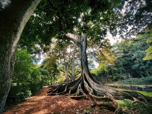
    Banyan tree is worshipped as a symbol of longevity, connectedness, life’s stability and strength. This tree is a connecting link between generations due to its long years of survival or lifespan. The tree has witnessed many centuries, attaining giant aerial roots over the years and remains symbolic of growth, connectedness, stability and longevity.

    Banyan tree is  regarded as the symbol of Trimurti- Lord Brahma, Vishnu and Shiva according to Hinduism and it is worshipped very fervently in the subcontinent. The tree is considered as immortal as per the vedic traditions.

     Banyan tree has gained significance beyond the spiritual realm and it is often regarded as a symbol of fertility, longevity and stability gathering the sobriquet tree of life. It is the national tree of India.

     Indian subcontinent has numerous centuries old Banyan trees and Sagar in Madhya Pradesh has a Banyan tree which is believed to be 5000years old.

    Ficus benghalensis or Banyan tree is an evergreen tree with wide spreading crown of green foliage and grows to a height of 20-30 meters. It is an epiphyte growing on the stem or branch of another tree and as it grows over the years numerous aerial roots are generated and these root hanging down to the earth touching the soil. Eventually these roots thicken and imparts strength and stability.

    Peepal tree [ Ficus religiosa]

    Peepal is known as Bodhi tree because it is under a Peepal tree The great Buddha achieved enlightenment. The tree has religious significance not only in Buddhism but also in Hinduism and Jainism.  The sacred fig is the tree of meditation and has given utmost significance in Indian state Odisha, Bihar and Haryana as the state tree.

    Ficus religiosa is a seasonal deciduous semi evergreen tree growing into the height of above 30m and trunk diameter up to 3 meters. Ficus is native to India and its neighboring countries like Nepal , Bhutan and Bangladesh etc. It grows in a wide variety of soils having good drainage for water. Ficus grows well in temperature range0-35 degree Celsius. It gross well in a wide variety of climates including tropical rain forest climate and tropical monsoon climate.

    The stories Sacred trees of India are innumerable and are infused intricately with the religion, tradition and culture of this land and it imparts fervent hues to the cultural heritage as well as lives of people of the subcontinent since antiquity.

    written by dr Sanjana p

    Image courtesy:https://www.freepik.com/free-photo/exotic-tree-with-roots-ground-middle-beautiful-forest_9283112.htm#fromView=search&page=1&position=8&uuid=e256ad2a-0da1-4265-9936-bd12aef12e13&query=+ficus++trees+with+aerial+roots

  •  The cultural & ecological significance of Khejri tree

     Khejri tree is one of the most beloved trees of Indian subcontinent, with its distinctive leaves and small yellow flowers and the tree grows in arid, dry climate with tolerance to adverse weather.

    Prosopis cineraria is the scientific name of this special tree which is intricately linked to the culture and traditions of Indian subcontinent since ancient times. Prosopis belongs to the pea family, Fabaceae.

    Prosopis cineraria is the state tree of Rajasthan where it is known as khejri. This tree is known by various names in different parts of the country. In Western Uttar Pradesh it is known as chhonkara and inTelangana  it is known as jammi. It is well-known in Madhya Pradesh& Maharashtra as Shami. Gujrati people of India knows the tree as khijro.

    Its adaptability to arid & dry climatic conditions has imparted it ecological significance as the preserver of soil and biodiversity sustainability.

    Khejri -the star of deserts all over the globe

     Prosopis cineraria [khejri tree] is native to arid portions of Western Asia and the Indian Subcontinent. It is cultivated in Afghanistan, Bahrain, Iran, India, Oman, Pakistan, Saudi Arabia, the United Arab Emirates, and Yemen. It is the national tree of the United Arab Emirates.

    The story of human sacrifice for khejri tree & the chipco movement

    In 1730 AD, the village of Khejarli near Jodhpur in Rajasthan witnessed a scene of violent & vehement environmental confrontation. Maharaja Abhai Singh of Marwar had ordered to cut khejri trees of the region to build a new palace there. A family resided in that region including Amrita Devi and her three young daughters gave their lives in an attempt to protect some khejri trees. This incident led to widespread protest and resentment and later turned into a massive movement in which 363 people were killed in the attempt to save the trees. In hindsight, this tragic incident compels us to have a look at the cultural significance of the tree in the history of Indian landscapes & vegetations.  Khejri was part of their ethnic culture and lives rather than the environmental significance the tree connotes currently.

     Later in the 1970s, the memory of this sacrifice led to the start of the Chipko movement in India which raise voice against cutting trees indiscriminately.

    Kejri – A sacred linking with the myth

     The Indian epic Mahabharata narrates the story of the Pandavas spent their thirteenth year of exile in disguise in the kingdom of Virata. Before entering the kingdom of Virata, they hung their celestial weapons on the khejri [Shami]tree for safekeeping for a year. When they returned after a year, they found their weapons safe in the branches of the Shami tree. It is narrated in the epic that before taking their weapons from the Shami tree, the Pandavas worshipped the tree and thanked it for keeping their weapons safe. It is curious to know that in Indian subcontinent every landscape and vegetation has a sacred linking with divinity as well as myths. Khejri is one of the such instances of trees being part of the culture and traditions of a spiritually inclined ancient society.

    Khejri tree -Botanical description

    The tree is found in extremely arid conditions, with rainfall as low as 15 cm (5.9 in) annually. Prosopis cineraria is a small tree, ranging in height from 3–5 m (9.8–16.4 ft). The leaves are bipinnate, with seven to fourteen leaflets on each of one to three pinnae. Branches are thorned along the internodes. Flowers are small and creamy-yellow and followed by seeds in pods.

    The plant has tolerance for highly alkaline and saline environments and thrive in these localities also.

    Kejri tree- A cultural link with Dussehra

    The tree is revered by Hindu community in Inda and it is intricately connected with Dusshera festival. On the tenth day of the Dasara Festival the tree has some special significance.

    In the Deccan region of India, as part of the tenth-day ritual of Dussehra, the marathas used to shoot arrows onto the crown of the khejri tree and gather the falling leaves into their turbans.

    Mysore Dasara &Banni [ kejri] tree

    According to historical references, Prosopis cineraria is known as the Banni mara, and holds a special place in the Mysore Dasara, where it’s worshipped on the Vijay-dashami day.

    Conservation efforts for the Khejri Tree focus on promoting sustainable land management practices, afforestation initiatives, and the preservation of natural habitats. Protection and restoration of Khejri-dominated ecosystems contribute to the maintenance of biodiversity and sustainable use of this resilient species.

    Khejri – Ecological warrior against soil erosion and climate crisis

    Currently the entire world is grappled with climate crisis as the aftereffect of global warming. At another end landslides and soil erosion are continuously morphing the landscape of our habitat and ecosystem. In the wake of these grave scenarios, Khejri tree due to its adaptability to adverse weather conditions and survival in arid regions helps to mitigate the impact of climate crisis and soil erosion indirectly. Therefore we can call the plant as an ecological warrior which preserve the ecosystem with its deep roots and leaves.

    As the Chipco movement advocates for preservation of trees, let us Embrace the trees , stop cutting and felling them down as long as no direct imminent threat of trees falling and endanger human lives under torrential rain and tempests. The term “Chipko” means “to hug” or “to embrace”. Let us embrace this tree and many others of its kind into human culture as well as lives to preserve our ecosystem and delve into our roots to imbibe the good practices of ancient wisdom.

    Written by Dr. Sanjana .P. Souparnika

    References for further reading

  • The Great Himalayan National Park

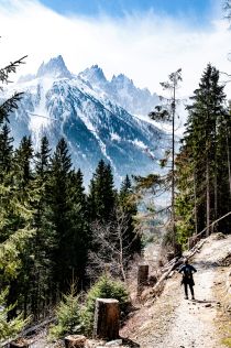
    The great Himalayan national park, a UNESCO World Heritage Site and a biodiversity hotspot is located in Banjar sub-division of Kullu in the state of Himachal Pradesh, India.

    This amazing Park in the western part of the Himalayan Mountains is characterized by high alpine peaks, alpine meadows and riverine forests. It is part of the Himalaya biodiversity hotspot and includes twenty-five forest types.

    Historical geography of the region

    The national park and biodiversity hotspot lies within the ecologically distinct Western Himalayas at the junction between two of the world’s major biogeographic realms, the Palearctic and Indo-malayan Realms. Displaying biotic elements from both these realms.

    The evolution of this region is related to tectonic plate movements. Over 100 million years ago, the Indian sub-continent broke off from the large, southern landmass, Gondwanaland and moved north. It eventually slammed into the northern land mass, Laurasia, and formed the gigantic folded mountains of the Himalaya.

    Due to this union of Gondwanaland and Asiatic landmasses, exchange of flora and fauna was possible and this ultimately led to the unique biogeographical features in the region.

    Biodiversity of the Great Himalayan National Park

     The park was established in 1984 and it spreads over an area of 1171 km2. It is a habitat to numerous floras and incorporates more than 375 fauna species, including approximately 31 mammals, 181 birds, 3 reptiles, 9 amphibians, 11 annelids, 17 mollusks and 127 insects. It is indeed an ethereal experience to walk amidst the snow cladded muntain valley forests exploring its rich biodiversity.

    This ecologically fragile region is protected under the strict guidelines of the Wildlife Protection Act of 1972. The high elevation ecosystem of the Northwest Himalaya has common plant elements with the adjacent Western and Central Asiatic region.The4,100 m elevation range of the park has a diversity of zones with their representative flora and fauna. The high elevation ecosystem incorporates alpine, glacial, temperate, and subtropical forests.

    Most of the Himalayan fauna has been protected under the high priority protection category of Schedule I of the Indian Wildlife (Protection) Act, 1972. The state government of Himachal Pradesh has banned hunting in the state for more than ten years. It is a commendable

    The park is home to a wide variety of vegetation ranging from pines ,spruces and the horse chestnuts of the lower valleys, to the alpine herbs and junipers.

    On this part of Western Himalayas, forests and alpine meadows can be seen in  their pristine forms. The subalpine zone is richest in species, followed by the alpine and upper temperate zones.

    The  Great Himalayan National Park Conservation Area is an epitome for elucidatting the significance of biodiversity conservation.

    It is located within the globally significant “Western Himalayan Temperate Forests” eco-region. The National Park Conservation Area is home to 805 vascular plant species, 192 species of lichen, 12 species of liverworts and 25 species of mosses.

    Trekking & Tourism prospects in the great Himalayan national park

    The park has emerged as a popular trekking and ecotourism destination. The GHNP office at Sai Ropa issues the permits needed for trekking. There are several popular trekking routes in the park, ranging from those that can be done in a day or two, to those that can take up from a week to ten days.

    How to reach the Great Himalayan national park?

    By air :

     Fly to Kullu Manali Airport (Bhuntar) from Delhi, and then traveling by road to the park’s entrance.[ about 60 km from the park].

     You need a permit to enter the park, which can be obtained from the park’s head office in Shamshi or zonal offices in Ropa and Shairopa. The park is only accessible by foot, and trekking is the only way to truly explore its wilderness.you can hire a guide.

    By train :

     Joginder Nagar is the nearest railhead, about 143 km away

    By road :

    Aut is the  major stop on the Kullu-Manali highway, Aut is the gateway to the park and Parvati Valley. From Aut take a taxi or local bus to Banjar.

    Written by Dr. sanjana.p. Souparnika

    References

  • Bhedaghat   & Dhuandhar  falls of Narmada river.

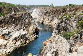
    It is a famous tourist destination in Jabalpur district well known for its incredible natural beauty, marble situated on the sides of the Narmada River which flows through the gorge.

     Bhedaghat has a famous water falls known as Dhuandhar Falls. Bhedaghat has been added on UNESCO list of natural world heritage sites.

    Location:

    Bhedaghat is located in Jabalpur district in the state of Madhya Pradesh, India. It is situated by the side of river Narmada and is approximately 20 km from Jabalpur city.

    Narmada river is the 5th longest river in India and the longest west-flowing river in the country. It is also the largest flowing river in the state of Madhya Pradesh. It is one of the rivers in India that flows in a rift valley, bordered by the Satpura and Vindhya ranges. The source of the Narmada is a small reservoir, known as the Narmada Kund, located at Amarkantak in the Anuppur District [Madhya Pradesh].

    Narmada -Through the veil of myths & beliefs

    In Indian subcontinent landscapes and rivers have a sacred linking with mythology. Narmada River is not an exception and which is considered as a goddess as well as a river in Hindu mythology. The Matsya Purana states that all of the banks along the Narmada are sacred.

    According to Hindu mythological stories and legends the Narmada was created from Shiva’s perspiration while he was performing penance on Mount Riksha and therefore the Narmada River is considered as Shiva’s daughter.

     As per another legend, the river Narmada has a different story of origin. The two teardrops fell from the eyes of Brahma [ the creator of the universe] started flowing as two rivers – the Narmada and the Son River.

    The pebbles of Narmada River also speak a story of mythological linking. Narmada Riverbeds’ pebbles are known as banalinga. The pebbles are made up of white quartz and are linga shaped [ Shiv linga]. They are believed to be the personified form of Shiva.

    The Narmada River is also worshipped as mother goddess Muktidayani, or liberating mother.

    Dhuandhar Falls

      The Narmada  river descends from Sonmuda, then falls over a cliff as Kapildhara waterfall and meanders in the hills, flowing through a tortuous course crossing the rocks and islands up to the ruined palace of Ramnagar. The river then runs north–west in a narrow loop towards Jabalpur. Close to Jabalpur city , at Bedaghat the river forms Dhuander falls.

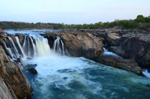
    This waterfall is located on the Narmada River in Bhedaghat and the fall is 30 meters high. Dhuandhar waterfalls   can be accessed from the east bank as well as the west bank of the Narmada River.

    The Narmada River, making its way through the world-famous Marble Rocks, narrows down and then plunges into a waterfall known as Dhuandhar. The plunge creates a bouncing mass of mist. The waterfall creates a smoky atmosphere and hence it is known as Dhuander fall. The word ‘Dhuandhar’ is derived from two Hindi words Dhuan which means smoke and Dhar meaning flow.

    This huge waterfall can be heard from a far distance as water plunges with intense force.

    To view the other side of Dhuandhar Falls, cable car service is available at Bhedaghat. The ropeway facility starts from the east bank of the Narmada River, crosses the river and then drops tourists off at the river’s west bank

    Bhedaghat a favourite shooting location for Hindi movie makers

    Many famous and superhit movies have been shot in this hilly terrain.

    The Hindi film Asoka was shot in Bhedaghat among the marble rocks by the Narmada River [2001].

    The crocodile fight scenes of the Hindi film Mohenjo Daro also are shot at Bhedaghat[2016].

    How to reach Bhedaghat?

    The nearest railway station is Bhedaghat Railway station. It is possible to take a tempo (auto-rickshaw) from Jabalpur to Bhedaghat. Its distance from the main city is about 28 km. The nearest airport is Jabalpur.

    References

  • Pachmarhi  – The queen of Satpura

     Pachmarhi is a hill station near the Satpura range of Mountains in Madhya Pradesh ,India. It is a treasure trove of rich history with its hilltop caves and is blessed immensely by it rich forests and water falls.

    Pachmarhi is situated in a valley of the Satpura Range and is widely known as Satpura ki Rani or Queen of Satpura. Most of its land area is under the administration of the Pachmarhi Cantonment Board, which serves the Indian Army.

    Location

    Pachmarhi is  a  small hill station in Hoshangabad district of Madhya Pradesh state of central India. It has an altitude of 1067. Dhupgarh, the highest point (1,352 meters) in Madhya Pradesh and the Satpura range, is located close to it.The town is wholly located within the Pachmarhi Biosphere Reserve and the Satpura Tiger Reserve.

    Climate

    The average temperature of this place is 21.7 °C and the average annual rainfall in is 2012 milimeters. May is the hottest month of the year, with an average temperature of 30.3 °C, while December is the coldest month of the year, with an average temperature of 15.5 °C.

    Pachmarhi – The queen of Satpura

     The hill station has a sacred linking with mythology through its hilltop caves which are well-known as the ‘Pandavs Caves’. According to a legend, these caves were built by five Pandava brothers of Mahabharatha era during their thirteen years of exile.

    Pachmarhi is a year-round tourist destination due to its pleasant weather, however during monsoon and winter season accentuate the charm of its landscapes.

    A tour through Pachmarhi may lead you to hill top cave temples and one of the prominent cave temples is Jata Shankar cave, deriving its name from the peculiar rock formation that looks like the matted dreadlocks [Jata] of Lord Shiva.

    Dhupgarh is another viewpoint of the Satpura Range[highest point is 1,352 m] well known for its sunrise and sunsets. The night view also has its own exquisite aesthetic appeal with the glimmering lights of  neighboring town Itarsi. The

    Sangam, a conflux of mountain streams behind Dhupgarh flows incessantly with its crystal-clear water down the valleys in almost all seasons as silvery lines over the mountain ranges.

    PanarPani is yet another natural freshwater lake of Pachmarhi with dense forest surrounding it.

     The Chauragarh fort is also a widely known spot for sunrise viewing. During the festivities of Nagpanchami and Mahashivratri, devotees flock to Chauragarh temple in large numbers, leaving about 2 lakh trishuls as offerings to Lord Shiva which are kept in front of the temple and also on the way to the temple.

    Some of the important places to visit in Pachmarhi

    Rajat Prapat  waterfall

    Bee Fall

    Bada Mahadev

    Gupt Mahadev

    Chauragarh (visited by devotees during Mahashivratri)

    Dhupgarh (the highest peak of the Satpura range)

    Handi Khoh (deep valley)

    Apsara Falls (fairy pool)

    Jata shankar cave (stalagmite-filled cave in a deep ravine)

    Dutchess Fall

    Pachmarhi Hill

    Pansy Pool

    Waters Meet

    Picadilly Circus

    Patharchatta

    Crumps Crag

    Lady Robertson’s View

    Colletin Crag

    Mount Rosa

    Reechgarh

    Rajendra Giri gardens

    Bansri Vihar

    Little Fall

    Naagdwari

    Draupadi Kund

    Twynham Pool

    Chhota Mahadev

    Nandigad

    History of Pachmarhi

    The ancient history of this region is still obscure as a mountain range which was less inhabited by people. It is known that the hill station was connected with the Bhonsle Kingdom and was later ruled by the Marathas in the 18th century.

    It was later part of the Gondi kingdom of Bhagvat Singh in the 19th century, although there was no permanent settlement at that time.

    The Chauragarh fort  was built by king Sangram Shah of the Gond dynasty. It was developed by SenaSahebSubha Janoji Maharaj of Nagpur। from the Maratha Era the Pilgrimage from Nagpur Start।.

     The origins of modern Panchmarhi can be traced back to 1857, when Captain James Forsyth of the British Army and Subhedar Major Nathoo Ramji Powar noticed the plateau while en route to Jhansi. It quickly developed into a hill station and sanatorium for British troops in the Central Provinces of India, and Powar was made Kotwal or army chief of the locality.

    Pachmarhi biosphere reserve

    It is a UNESCO listed Biosphere reserve  with its rich flora and fauna. The total area of Pachmarhi Biosphere Reserve is 4981.72 km2. The reserve spans parts of three civil districts, viz; Hoshangabad (59.55%), Chhindwara (29.19%) and Betul (11.26%)

    UNESCO added the Pachmarhi area to its list of Biosphere Reserves in May 2009, due to the many rare plant species in the vicinity. It includes three wildlife conservation units  – Bori Sanctuary 485.72 km2), Satpura National Park (524.37 km2) and Pachmarhi Sanctuary (491.63 km2)

    The Satpura Tiger Reserve contains several large mammal species, including the tiger, leopard, wild boar, gaur (Bos gaurus), chital deer (Axis axis), muntjac deer, sambar deer (Cervus unicolor), and rhesus macaques.

    The endemic fauna also includes chinkara, nilgai, wild dogs, the Indian wolf, bison, Indian giant squirrels, and flying squirrels.

     The biosphere reserve includes fruit trees such as mangoes, jamun, custard fruit, and lesser-known local fruits such as khatua, tendu, chunna, khinni, and chaar. Oak and blue pine are also found here  abundantly.  the forest is also known for having many medicinal plants and herbs.

    Waterfalls of Pachmarhi

    Silver Falls or Rajat Prapat, is falling from a height of 350 feet and looks like a silver strip when sunlight falls on it, hence is called Silver Falls.

    Apsara Vihar Falls is just a 10-minute downhill trail and one of the most beautiful falls in Pachmarhi. It is believed that during the British era, beautiful British women used to bathe here and the locals thought of them to be apsaras and hence the pool was named Apsara Vihar.

    Bee Falls or the Jamuna Prapat is the most magnificent waterfall and is just 5 km from the Pachmarhi bus stand. Cascading down from a height of 150 feet, the fall is named as such because from a distance the waterfall sounds like a bee as the water flows through the rocks and makes a buzzing sound.

    How to reach Pacmarhi?

    The nearest airport is Raja Bhoj Airport in  Bhopal (around 222 km) which has daily flight services from Delhi and Mumbai and 13 major cities of India.

     Cabs are available from Bhopal to Pachmarhi. Jabalpur airport to Pachmarhi is also just 300 km

    Pachmarhi is just 54km by road from the Pipariya railway station. Several direct trains link Pipariya with important cities of India.

     If one want to travel by road many state-owned and private buses are available for Pachmarhi from nearby cities like Bhopal, Jabalpur, Nagpur, Indore.

     Stay & Accommodation

     The hill station has numerous hotels and resorts.

    Refereces

    1. https://www.mptourism.com/
    2. https://www.pachmarhi.com/
    3. https://web.archive.org/web/20141028175430/http://www.sify.com/news/fullstory.php?a=jf1u4rjejdc&title=Three_Indian_sites_added_to_UNESCO_list_of_biosphere_reserves
    4. https://imdpune.gov.in/library/public/Climatological%20Tables%201991-2020.pdf
    5. https://en.wikipedia.org/wiki/Pachmarhi
    6. image courtesy -dreamstime.com
  • Microbes to detoxify our atmosphere & reduce global warming

    Microbes play a vital role in reducing air pollution and global warming. Let us have a glimpse at the role of microbes in carbon sequestration and in climate change.

      Microbes are microscopic living things found in water, soil, the air and our bodies. Microbes are also referred to as microorganisms and some of them are disease causing agents while others are helpful to the body as well as the environment. The microbes include bacteria, viruses and fungi and they are part of our life and environment.

    It is a well-known fact that human body contains numerous microbes and every microorganism is not harmful to us.  For example, human intestine contains probiotic bacteriae and vitamin K synthesizing bacteriae which helps to maintain the gut health. Similarly, our environment also incorporates microbes as a part of our ecosystem and which helps to maintain ecological balance.

         Melbourne researchers have discovered that microbes of our environment consume huge amounts of atmospheric carbon monoxide (CO) and helps in detoxification process. CO is a green house gas which leads to global warming phenomenon due to their increased heat trapping potential. 

    The Monash University-led Study, published in Nature Chemical Biology, shows that at an atomic level how microbes consume carbon monoxide present in the atmosphere. The microbes use a special enzyme, called the CO dehydrogenase in this detoxification process. These microbes consume CO for their own survival, but it helps to clear carbon monoxide, the toxic gas that gets trapped on Earth’s atmosphere.

    Microbes reduce air pollution

    Carbon monoxide [CO] is an atmospheric trace gas and rarely exceeds 1 ppm except in heavily polluted city airspaces, volcanic exhalations, or industrial flue gases . Volcanic exhalations have significant CO content, submarine hydrothermal vent fluids have about 100 nM CO .

    Moderate concentrations of CO are produced by bacterial fermentation or in soil associated with rhizosphere bacteria. CO has high potential as an electron donor, and represents a very favorable energy and carbon source for microbial growth. Some atmospheric microbes utilize atmospheric carbon monoxide as a part of their survival process, but this detoxification process by the microbes has positive impact on our ecosystem as it reduces air pollution, which kills many millions of people each year.

    Microbes impact global warming

      According to NASA, Global warming is the long-term heating of Earth’s surface observed since the pre-industrial period (between 1850 and 1900) due to human activities , primarily fossil fuel burning, which increases heat-trapping greenhouse gas levels in Earth’s atmosphere. Since the pre-industrial period, human activities are estimated to have increased Earth’s global average temperature by about 1 degree Celsius (1.8 degrees Fahrenheit), a number that is currently increasing by more than 0.2 degrees Celsius (0.36 degrees Fahrenheit) per decade.

    Generally, life on Earth depends on energy coming from the Sun. About half the light energy reaching Earth’s atmosphere passes through the air and clouds to the surface, where it is absorbed and radiated in the form of infrared heat. About 90% of this heat is then absorbed by greenhouse gases and re-radiated, slowing heat loss to space. Greenhouse gases are slowing heat loss from the lower atmosphere.

    The consumption of carbon monoxide [CO]by the microbes help to reduce global warming, as CO is a notoriously known for raising atmospheric temperature as a greenhouse gas. Five key greenhouse gases are carbon dioxide, nitrous oxide, methane, chlorofluorocarbons, and water vapor.

    History of link between microbes and environment

     The evidence for CO utilization by “methane bacteria” was noted by Kluyver and Schnellen in 1947 and since then many microbes using CO via oxidation have emerged. Many strains of microbes use molecular oxygen as the electron acceptor for aerobic oxidation of CO.

    Carbon monoxide (CO) is one of the most important chemical reactants in the troposphere layer of earth’s atmosphere. It influences the fate of methane and ozone by removing the major atmospheric oxidizing agent, hydroxyl radical.

    Fossil fuel use, biomass burning, and oxidation of atmospheric hydrocarbons (methane and other compounds) account for most of the CO source strength of the atmosphere.

    Carbon dioxide sequestration

    Soil microbes are essential to carbon sequestration. Certain bacteria and algae convert carbon dioxide into organic matter, which is then stored in the soil. This helps remove excess carbon dioxide from the atmosphere, mitigating the effects of global warming.

    Some of the key soil microbes involved in carbon sequestration include:

    Mycorrhizal fungi: These fungi form mutualistic relationships with plant roots, helping plants to absorb nutrients and water from the soil. They also play a role in carbon sequestration by increasing the amount of carbon stored in the soil.

    Actinobacteria: These bacteria are known to decompose plant litter and other organic matter, releasing carbon dioxide in the process. They also play a role in carbon sequestration by producing organic compounds that help to stabilize soil organic matter.

    Rhizobia: These bacteria form symbiotic relationships with legume plants, fixing nitrogen from the air and making it available to the plant. This process also helps to increase the amount of carbon stored in the soil.

    Arbuscular mycorrhizal fungi: These fungi form symbiotic relationships with a many plant species, and they play vital  role in carbon sequestration by increasing the amount of carbon stored in the soil.

    Proteobacteria: These bacteria help in decomposing plant litter and other organic matter, releasing carbon dioxide. However, they aid carbon sequestration by producing compounds that help to stabilize soil organic matter.

    Scientists have recently discovered a microbe, a type of cyanobacteria, off the coast of a volcanic island near Sicily that consumes carbon dioxide (CO2) very quickly. Cyanobacteria are a type of bacteria that use photosynthesis to obtain energy, capturing carbon in the process.

    Together with a team of researchers from Harvard and Cornell universities in the US and the University of Palermo in Sicily, and with help from the Vulcano community, Tierney isolated a microbe that converted CO2 into biomass faster than other known cyanobacteria.

    How do microbes impact climate change?

    Scientists  all over the world are of the opinion that tackling climate change will require large-scale carbon capture and carbon sequestration. Both aims at removing excess carbon dioxide from the atmosphere and thus prevent the climate change.  This can probably be achieved via new technology or through protecting and enhancing existing natural ecosystems such as forests, peatlands and soils.

     Last year the UN’s Intergovernmental Panel on Climate Change (IPCC) said that carbon capture is essential because even big cuts to emissions won’t be enough to limit global warming. Microbes play a crucial role in caron capture.

    This discovery elucidates the significance of coexistence of microbes in our environment for better weather and climatic state. All microbes are not deleterious to our health in normal weather and climatic conditions. Some are helpful in preserving the equilibrium of our ecosystem.

    written by

    Dr. Sanjana.p. Souparnika

    References for further reading

  • Sustainable living

    Sustainable living is a method of reducing one’s “carbon footprint”. In this life style people learn to minimize their use of Earth’s resources and reduce the personal and environmental impact. It also includes healthy organic food choices.

    Sustainable living means we prioritize the use of natural and renewable resources instead of creating excess waste and depleting environmental resources for future generations. Sustainable living can counteract climate change and other negative environmental concerns happening from human activity of exploiting natural resources.

    Sustainable living is a practical life style choice or philosophy that aims to reduce personal and environmental impact by making positive changes.

    More precisely, sustainable living is a method of reducing one’s “carbon footprint”.

    In this life style people learn to minimize their use of Earth’s resources and reduce the  personal and environmental impact.

    Sustainability or sustainable living was an idea proposed to create and maintain the conditions under which humans and nature can exist in productive harmony to support present and future generations.

    Living sustainably means” curb expenditure” in order to protect and improve our environment.”

        The natural resource base to supply food is being threatened by overfishing, land degradation, and more human activities exploiting natural resources. All these unbridled exploitations are polluting the world’s freshwater supplies faster than nature can purify them, and excessive use of water is contributing to global water stress. And household energy usage is contributing to 21 percent of consequential CO2 emissions.

    A few sustainable living options

    ·       Empower organic farmers & people with agricultural and financial support they needed to make a fair living without cutting down trees.

    ·       Don’t use plastic bags at checkout. Instead, take your own bags for groceries.

    ·       Buy your grains & groceries in bulk from your local farmer’s markets.

    ·       Avoid buying plastic-wrapped products, opt for a paper bag instead.

    ·       Stop buying bottled water. Use your own steel or glass bottles filled with water.

    ·       Shop at bulk food stores for any goods, avoid frequent food travels. Better take products in your own jars or bags.

    ·       Take your own paper bags or a container when buying snacks .

    ·       Support fashion brands that are ethical and environmentally conscious.

    ·       Learn how to find sustainable materials when shopping.

    ·       Go paperless to avoid deforestation or falling down trees for making paper.

    ·       Opt to receive digital letters and notices.

    ·       Send electronic wedding invitations.

    ·       Collect scrap paper in a tray.

    ·       Turn off your computer before leaving work.

    ·       Get rid of your home printer.

    ·       Unplug workstation from ports overnight to reduce phantom power.

    ·       If you need business cards, use an eco-friendly printer.

    ·       Add small pot plants to your workspace. Adopt green office environment

    ·       Always use double-sided printing where possible.

    ·       Juice the off-cuts of your vegetables and fruits.

    ·       Repurpose glass jars usage.

    ·       Use washable metal straws instead of disposable plastic straws.

    ·       Limit the use of hot water when hand washing dishes.

    ·       Use cloths instead of paper towels.

    ·       Make your own coffee instead of buying takeaway.

    ·       Ditch your bin liner or use newspaper instead.

    ·       Start composting the vegetable and food waste.

    ·       Reduce your food waste by eating only what you need.

    ·       Invest in a pressure cooker and reduce your cooking time and save energy.

  • Sharavati river basin

    Sharavati river

    Sharavati is one of the well known rivers flowing through Karnataka state ,India and major part of the river basins lies in the western ghats.

    Sharavati river flows through Shivamogga and Uttara Kannada districts of Karnataka. The river is around 128 km long and it joins the Arabian Sea at Honnavar in Uttara Kannada district.

     On its way to Arabian Sea, the Sharavati forms the Jog Falls [ in Siddapur taluk ,Uttarakannada district] where the river falls from a height of 253 m.

    The river is dammed at Linganamakki. This part of the river above the dam is upstream and the remaining is downstream. The Linganamakki dam located in the Sagar taluk has a length of 2.4 km  and was constructed across the Sharavati river in 1964.

     The major tributaries of the river are Nandihole, Haridravathi, Mavinahole, Hilkunji, Yennehole, Hurlihole, and Nagodihole

    Origin of the river and myth


      Indian geography and landscapes are intricately connected with mythology, epics and religious sentiments of the country. As Diana .L. Huc describes in her book ‘ India a sacred geography ‘ each and every landscapes including rivers, mountains and forests of this land are elaborately linked to the stories of gods & heroes of myths & epics. The Sharavati river also is not an exception to this sacred connection.

         Sharavati originates at a place called Ambutheertha in the Thirthahalli taluk. According to ancient legend, the Hindu god Rama [ Of epic Ramayana] shot at the ground with his Ambu (arrow) to quench the thirst of his consort sita devi. When his arrow hit the ground, water[ Thirtha] poured out. This location of origin of the River is known as thirthahalli [  which translates into” A hamlet of water”]. The river which originated from an arrow later known as “Sharavati” as “Shara” translates to arrow.

    Indian subcontinent has an amazing number of myths and legends, rituals and festivities connected with its geography & landscape. It denotes that ancient people of India had given supreme reverence to nature and regarded everything they received from nature as gifts of God. In Indian subcontinent the landscapes are not only connected with Hinduism, but also they have been linked to Buddhism, Jainism and various other religions of the subcontinent. If the historical geography of any particular landscape is studied it may point out that the rivers, mountains and other landscapes were part of many literary documents.

    Sharavati river basin- Climate, Biodiversity ,Wild life

    The river basin lies in Uttara Kannada and Shivamogga districts of Karnataka,India.  The  Sharavati river basin gets a large amount of rainfall. Mean annual rainfall ranges from 6000 mm in the western side to 1700 mm in the eastern side of the basin. Monsoon in July fills the river abundantly.

    Generally the climate is cool [22.2degree Celsius]. Humidity exceeds 75% for most times of the year. During the months of monsoon, the relative humidity during the afternoons is approximately 60%.

    The Sharavati river basin is rich in biodiversity. In a survey conducted in the basin, 23 amphibians belonging to the families of Bufonidae, Ichthyophiidae, Microhylidae, Ranidae and Rhacophoridae were recorded.

    The Sharavati waters contain a few special species of fishes which are named after the river.These include:

    Batasio sharavatiensis: A bagrid catfish discovered near Jog Falls, Uttara Kannada district.

    Schistura sharavatiensis: A fish species discovered in Sharavati river near Algod, Shimoga district.

    Two new species of diatoms were also discovered from Hirebhaskeri Dam of Sharavati River in 2011.

    A part of the Sharavati river basin was declared as a wildlife sanctuary on 20 April 1972

    Sharavati wildlife sanctuary

    The river basin is home to many species of plants and animals. Due to the presence of rich biodiversity a part of the Sharavati river basin was declared as a wildlife sanctuary on 20 April 1972.  The wild life sanctuary is spread over an area of 431.23 km2 , it has dense evergreen and semi-evergreen forests. The vegetation here ibnclude evergreen, semi-green and some moist deciduous forests.

     Trees in the evergreen forest include species such as Dipterocarpus indicus, Calophyllum tomentosum, Machilus macrantha, Caryota urens and Aporosa lindleyana. In the semi-evergreen and moist deciduous forests, common species include Lagerstroemia lanceolata, Hopea parviflora, Dalbergia latifolia, Dillenia pentagyna, Careya arborea, Emblica officinalis, Randia sp., Terminalia sp. and Vitex altissima.

    The altitude in the sanctuary varies from 94 m to 1102 m, the highest point being Devarakonda on the southern edge of the sanctuary.

    Linganamakki reservoir

    Linganamakki reservoir, with an area of 128.7 km2 , is a part of this sanctuary. The remaining area has been divided into core zone (74.33 km2.), buffer zone (170.67 km2) and tourism zone (57.53 km2). Honnemaradu is an island on the reservoir formed by the Linganamakki dam. It is located in the Sagar taluk of Shimoga district. This place is popular for water sports, such as canoeing, kayaking and wind surfing.

    The wild life including the animal species is varied in the sanctuary. It is home to the endangered lion-tailed macaque. Other mammals include tiger, leopard (black panther), wild dog, jackal, sloth bear, spotted deer, sambar, barking deer, mouse deer, wild boar, common langur, bonnet macaque, Malabar giant squirrel, giant flying squirrel, porcupine, otter and pangolin.

     Reptiles are also part of the wildlife here and include king cobra, python, rat snake, crocodile and monitor lizard.  Sharavati river basin wild life sanctuary has numerous birds also. Some of the avian species include hornbill, paradise flycatcher, racket-tailed drongo and Indian lories and lorikeets.

    How to reach Sharavati river basin?

    Nearest airport is Mangalore international airport. The distance by road from Manglore to sharavati is 200km. You can also reach from Bangalore airport.[274km].

    References

    • A Walk on the Wild Side, An Information Guide to National Parks and Wildlife Sanctuaries of Karnataka, Compiled and Edited by Dr. Nima Manjrekar, Karnataka Forest Department, Wildlife Wing, October 2000
    • https://en.wikipedia.org/wiki/Sharavati