The Himalayas are the majestic mountain ranges spreading over territories of six countries. The mountain ranges are the determinants of the climate and ecosystems of Indian subcontinent. Himalayas are intricately linked with myths of the land & has been a revered zone of divinity for various religions since antiquity.
The Himalayas extends over territories of six countries including India, China, Nepal. Bhutan, Pakistan and Afghanistan. The mountain range is involved in dispute related to sovereignty in Kashmir region among India, China and Pakistan.
Geographical borders of Himalayan ranges
The Himalayan range is bordered on the northwest by the Karakoram and Hindu Kush ranges, on the north by the Tibetan Plateau, and on the south by the Indo-Gangetic Plain.
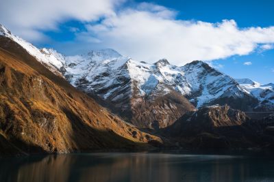
The mountain ranges contain some of the Earth’s highest peaks. The Mount Everest, more than 100 peaks exceeding elevations of 7,200 m (23,600 ft) above sea level lie in the Himalayas.
The word ‘Himalayas’ hails from the Sanskrit words hima and aalaya which means” abode of snow”.
Himalayas give origin to many rivers and its tributaries. The Indus, the Ganges, and the Tsangpo–Brahmaputra, rise in the vicinity of the Himalayas.
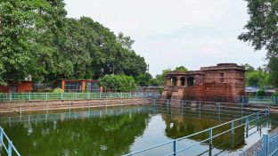
Himalayas through the veil of mythology
India has a unique culture and heritage which extends beyond its borders and profoundly shaped the cultures of South Asia and Tibet.
Rivers are the cradle of civilizations everywhere on the globe since prehistoric times. Mountains and rivers with their tributaries nourish and nurture life in their vicinity. Landforms and river banks have played a significant role in shaping the cultural heritage and beliefs of the subcontinent. The livelihoods of populations living along the riverbanks are dependent on the availability of water, crops, cultivation, aquatic life forms, etc.
Ancient tribes believed that mountains provided them security from invasions and sudden attacks; moreover, they believed that rain and river water originated from the mountain tops. Consequently, the ancient people who inhabited the subcontinent started worshipping mountains and rivers.
Many Indian hamlets still revere the local landforms, water bodies, and trees as gods and goddesses. This deep connection with nature transforms mountains and rivers into divine, personified figures.
This sacred linking can be traced in the texts and inscriptions of the entire subcontinent. Mountains were considered as holy as rivers, and ancient people believed that gods resided on mountain tops. Even today, most temples in India are built on mountains and in their valleys. Rivers have also been personified as goddesses. The story of the Himalayas, with its rich mythological connections, is phenomenal.
The word “Himalaya” is mentioned in ancient epics and purana texts as “Himavaan ” as a personified king and the goddess Devi Parvathi is regarded as the daughter of Himavan. Therefore, Himalaya mountain ranges have significant role in Indian mythology as sacred mountains in Hinduism and Buddhism.
Themount Kailash is regarded as the abode of Hindu god Shiva and his consort goddess Devi Parvati with their children. This mountain range is visited by millions of pilgrim tourists every year. The pilgrimage generally involves trekking towards Lake Manasarovar and a circumambulation of Mount Kailash. Hindus take a ritual bath in the Manasarovar lake before doing circumambulation.
Pilgrims believe that doing a circumambulation of Mount Kailash is spiritually uplifting towards salvation or liberation cleansing the impurities of minds.
Mount Kailash is located in Ngari Prefecture, Tibet Autonomous Region of China. The peak of Mount Kailash is located at an elevation of 6,638 m (21,778 ft), near the western trijunction between China, India and Nepal.
Mount Kailash is situated close to Manasarovar and Rakshastal lakes. The sources of four rivers: Indus, Sutlej, Brahmaputra, and Ghaghara lie in the vicinity of the region. Mount Kailash is sacred in Bon, Buddhism, Hinduism, and Jainism.
Hindu text Skanda Purana offers an interesting narrative about mount Kailash as follows:
“There are no mountains like the Himalaya, for in them are Kailas and Manasarovar. As the dew is dried up by the morning Sun, so are the sins of mankind dried up by the sight of the Himalaya.”
Kailash and Manasarovar are mentioned in the Hindu epics Ramayana and Mahabharata.
According to Jain scriptures, Rishabhadeva, the first Tirthankar of Jainism attained moksha (liberation) on Mount Kailash.
However, due to the beliefs of different faiths that revere Mount Kailash, setting foot on its slopes or attempting to climb it is forbidden by law.
Indian subcontinent has several such sacred linking with its geography. The rivers originating from Himalayas such as Indus, Ganges along with their tributaries are considered holy and this sacred linking is evident in Shiv purana.
The river Ganges is considered as goddess Ganga, a consort of lord Shiva and it is believed that Ganga is residing in the locks of Shivas hair and flows from there to earth. ‘The descend of Ganga ‘is a celebrated festival in Himalayan states of India and the mythology related to the descend of Ganga is intricately connected with Lord Shiva.
Geography of Himalayan mountain ranges
The Himalayas were uplifted after the collision of the Indian tectonic plate with the Eurasian plate. It is an ongoing collision which began approximately 50-55 million years ago. This intense continental convergence, following the closure of the Tethys Ocean, causes the crust to buckle and thicken, driving the rapid, continuous uplift of the mountain range at rates exceeding 1 cm/year.
The Himalayan mountain range extends west-northwest to east-southeast in an arc 2,400 km.
Its western anchor, Nanga Parbat, lies just south of the northernmost bend of the Indus river. Its eastern anchor, Namcha Barwa, lies immediately west of the great bend of the Yarlung Tsangpo River. The Indus-Yarlung suture zone, along which the headwaters of these two rivers flow, separates the Himalayas from the Tibetan plateau.
The rivers also separate the Himalayas from the Karakorams, the Hindu Kush, and the Transhimalaya ranges
The range varies in width from 350 km in the west to 151 km in the east
Mountain ranges of Himalayas -south to north
The Himalayas include four parallel mountain ranges from south to north:
The Sivalik Hills on the south; the Lower Himalayan Range; the Great Himalayas, which is the highest and central range; and the Tibetan Himalayas on the north. The Karakoram ranges are regarded as separate ranges from the Himalayas.
In the middle of the great curve of the Himalayan mountains lie the 8,000 m (26,000 ft) peaks of Dhaulagiri and Annapurna in Nepal, separated by the Kali Gandaki Gorge. The gorge splits the Himalayas into Western and Eastern sections, both ecologically and orographically – the pass at the head of the Kali Gandaki, the Kora La, is the lowest point on the ridgeline between Everest and K2 (the highest peak of the Karakoram range).
To the east of Annapurna are the 8,000 m peaks of Manaslu and across the border in Tibet, Shishapangma.
To the south of these is situated Kathmandu, the capital of Nepal and the largest city in the Himalayas. East of the Kathmandu Valley lies the valley of the Bhote/Sun Kosi river which rises in Tibet and provides the main overland route between Nepal and China – the Araniko Highway/China National Highway 318.
Further east is the Mahalangur Himal with four of the world’s six highest mountains, including the highest: Cho Oyu, Everest, Lhotse, and Makalu. The Khumbu region, well-known for trekking, is found here on the south-western approaches to Everest.
The Arun river drains the northern slopes of these mountains, before turning south and flowing to the range to the east of Makalu.
In the far east of Nepal, the Himalayas rise to the Kangchenjunga massif on the border with India, the third-highest mountain in the world, the most easterly 8,000 m (26,000 ft) summit and the highest point of India.
The eastern side of Kangchenjunga is in the Indian state of Sikkim. Formerly an independent Kingdom, it lies on the main route from India to Lhasa, Tibet, which passes over the Nathu La pass into Tibet.
East of Sikkim lies the ancient Buddhist Kingdom of Bhutan. The highest mountain in Bhutan is Gangkhar Puensum, which is also a strong candidate for the highest unclimbed mountain in the world. The Himalayas here are becoming increasingly rugged, with heavily forested steep valleys.
The Himalayas continue, turning slightly northeast, through the Indian State of Arunachal Pradesh as well as Tibet, before reaching their easterly conclusion in the peak of Namche Barwa, situated in Tibet, inside the great bend of the Yarlang Tsangpo river. On the other side of the Tsangpo, to the east, are the Kangri Garpo mountains. The high mountains to the north of the Tsangpo, including Gyala Peri, however, are also sometimes included in the Himalayas.
Far west from Dhaulagiri, Western Nepal,the home to Rara Lake exists. The Karnali River rises in Tibet but cuts through the centre of the region.
Further west of the border, the Sarda River provides a trade route into China, where on the Tibetan plateau lies the high peak of Gurla Mandhata.
Around the Lake Manasarovar lies the sacred Mount Kailash in the Kailash Ranges ,and close to it is the origin of the four main holy rivers of Himalayas which are revered in Hinduism, Jainism, Buddhism & Sufism.
In Uttarakhand, the Himalayas are named as the Kumaon and Garhwal Himalayas with the high peaks of Nanda Devi and Kamet.
Uttarkhand has several significant pilgrimage destinations such as Chota Chaar Dhaam, with Gangotri, the source of origin of the holy river Ganges, Yamunotri, the site of origin of the river Yamuna, and the temples at Badrinath and Kedarnath.
Himachal Pradesh, is popular Indian state with its hill stations Shimla and Dharamsala. This region marks the beginning of the Punjab Himalaya and the Sutlej River, the most easterly of the five tributaries of the Indus, cuts through the range here.
Further west, the Himalayas form the mountainous Jammu region and the renowned Kashmir Valley with the town and lakes of Srinagar.
The Himalayas form most of the south-west portion of the disputed Indian-administered union territory of Ladakh. The twin peaks of Nun Kun are the only mountains over 7,000 m (4.3 miles) in this part of the Himalayas.
The Himalayas extending into the western end in the dramatic 8000 m peak of Nanga Parbat, which rises over 8,000 m (26,000 ft) above the Indus valley and is the most westerly of the 8000 m summits. The western end terminates at a magnificent point near Nanga Parbat where the Himalayas intersect with the Karakoram and Hindu Kush ranges, in the disputed Pakistani-administered territory of Gilgit-Baltistan.
Some parts of the Himalayas, such as the Kaghan Valley, Margalla Hills, and Galyat tract, extend into the Pakistani provinces of Khyber Pakhtunkhwa and Punjab.
Apart from the geological and geographical significance The Himalayas are ecologically sensitive biodiversity hotspots , defence barrier and determinants of climate change in the subcontinent.
This majestic mountain ranges amaze the world for centuries with its splendour and grandeur and captivate adventure trekking lovers with its glorious peaks.