Tag: cave temples

  • Bhimbetka Rock Shelters

    Bhimbetka in Madhya Pradesh stands tall with the grandeur of seven hills and over 750 rock shelters  with cave paintings of ancient times, distributed over 10 km.

    It is a UNESCO World Heritage Site near Bhopal, renowned for its rock shelters and cave paintings. Bhimbetka has the oldest-known rock art in India, as well as it is one of the largest prehistoric complexes.

     The place name Bhimbetka originated from a myth related to Bhima of Mahabharatha . Bhimbetka means “Bhima’s resting place” or “Bhima’s lounge”.

    This amazing rock shelter consists of seven hills: Vinayaka, Bhonrawali, Bhimbetka, Lakha Juar (east and west), Jhondra and Muni Babaki Pahari

    South of these rock shelters are successive ranges of the Satpura hills. It is within the Ratapani Wildlife Sanctuary, embedded in sandstone rocks, in the foothills of the Vindhya Range.

    The Auditorium rock is the largest shelter at Bhimbetka. According to the accounts of Robert G. Bednarik this prehistoric cave has “cathedral-like” ambience with its Gothic arches and soaring spaces.

    There is an ancient Mata Vaishavi Temple in Bhimbetka.

    Location

    Bhimbetka rock shelter is situated at Bhojpur Raisen in Bhopal District about 45 kilometres south-east of Bhopal, at the southern edge of the Vindhya Range.

    Historical significance

    Bhimbetka is a scenic and picturesque site with it is world famous rock shelters  which throw light into the earliest traces of human life in India and evidence of the Stone Age starting at the site in Acheulean times.

    Some of the Bhimbetka rock shelters feature prehistoric cave paintings and the earliest are dated to 10,000 BCE, corresponding to the Indian Mesolithic.

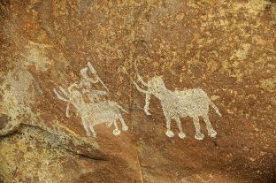
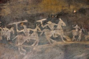
     These cave paintings depict various types of animals and human figures with early evidence of community living with dance and hunting from the Stone Age.  The paintings also depict warriors on horseback from a later time.

    Link with Mythology

     Indigenous people of Bhimbetka believes that Bhima during his exile used to rest here to interact with the locals. There is also a narrative that Bhima Worshiped Mata Vaishavi at this location and blessed for concurring the forthcoming war.

    Auditorium cave.

    The cave is one of the prominent features of Bhimbetka which throws light into the history of this place.  It is surrounded by quartzite towers.

    The cave’s plan is similar to a “right-angled cross” with four of its branches aligned to the four cardinal directions. The main entrance points to the east. At the end of this eastern passage, at the cave’s entrance, is a boulder with a near-vertical panel that is distinctive, one visible from distance and all directions – Chief’s Rock” or “King’s Rock]. The boulder with the Auditorium cave is the central feature of the Bhimbetka.

    Cave paintings of Bhimbetka unravel the evolution of a civilization

      The rock shelters and caves of Bhimbetka have a large number of paintings. Some of the oldest paintings are dated to 10,000 BCE.

    It was W. Kincaid, a British India era official who first mentioned Bhimbetka in a scholarly paper in 1888.But the archeological significance of this rock caves was found by V. S. Wakankar. However, the prehistoric significance of Bhimbetka was revealed only in the 1970s.

     There was human settlement here from the Stone Age through the late Acheulian to the late Mesolithic until the 2nd century BCE. The artefacts from the excavation site and the pigments present in deposits, as well as the rock paintings points to that.

     The drawings and paintings of Bhimbetka can be classified under seven different periods.

    V. S. Wakankar classified the drawings and paintings into seven different periods and dated the earliest paintings to have belonged to the upper Palaeolithic to be as early as 40,000 years ago

     The colours used are vegetable colours which have endured through time because the drawings were generally made deep inside a niche or on inner walls.

    Period I – (Upper Paleolithic): These are linear representations in green and include humans dancing and hunting.

    Period II – (Mesolithic): small figures in this group show linear decorations on the body. There is animal as well as human figures and hunting scenes with the weapons such as barbed spears, pointed sticks, bows and arrows. The types of weapons used are clear indicators to the periods of history.

     Tribal wars also have been portrayed here. The depiction of communal dances, birds, musical instruments, mothers and children, pregnant women, men carrying dead animals, drinking and burials are detected among the paintings.

    Period III – (Chalcolithic) – These resemble paintings of the Mesolithic. These paintings denote that during this period the cave dwellers of this area were in contact with the agricultural communities of the Malwa plains, exchanging goods with them.

    Period IV & V – (Early historic): The figures of this group have a schematic and decorative style and are painted mainly in red, white and yellow colors.

    The association is of riders, depiction of religious symbols, tunic-like dresses and the existence of scripts of different periods.

    The figures of yakshas, tree gods and magical sky chariots also have been found here.

    Period VI & VII – (Medieval): These paintings are geometric linear and more schematic, however they show degeneration and crudeness in their artistic style. The colors used in these paintings seems to be prepared by combining black manganese oxides, red hematite and charcoal.

    In one of the desolate rock shelters, the painting of a man holding a trident-like object and dancing has been found and it is assumed by many as Lord Shiva.

    Many paintings of Bhimbetka has been lost or degenerated overtime.

     It has been estimated that paintings of at least 100 rock shelters might have eroded away.

     Bhimbetka stands with its numerous rock shelters in the lush green valley of Vindya ranges, since many centuries unravelling the history of mankind. It offers new lessons for exploring our roots taking a stroll through the depth of the caves which unfolds the untold history of people who thrived here centuries and decades ago.

    How to reach Bhimbetka?

    By air : Raja Bhoj Airport is the major airport of Bhopal, located around 15 km from the city center in Bairagarh suburban area on National Highway 12. Bhopal is well connected to the metros other cities by various companies’ airlines.

    To reach Bhimbetka Rock Shelters from Bhopal, you can take a bus or taxi on NH46, which is about a 46 km drive.

    By rail: The nearest railway station to the Bhimbetka Rock Shelters is Bhopal Junction (BPL]. It is served by the West Central Railways. Bhopal is on one of the two main Delhi to Mumbai railway lines and also on the main line to the southern state capitals of Chennai, Hyderabad, Bangalore and Thiruvananthpuram.

    By road:

    The nearest bus stand to the Bhimbetka Rock Shelters is Obaidullaganj, which is about 9 km away, and buses from Bhopal can take you there.

    References

  • Pachmarhi  – The queen of Satpura

     Pachmarhi is a hill station near the Satpura range of Mountains in Madhya Pradesh ,India. It is a treasure trove of rich history with its hilltop caves and is blessed immensely by it rich forests and water falls.

    Pachmarhi is situated in a valley of the Satpura Range and is widely known as Satpura ki Rani or Queen of Satpura. Most of its land area is under the administration of the Pachmarhi Cantonment Board, which serves the Indian Army.

    Location

    Pachmarhi is  a  small hill station in Hoshangabad district of Madhya Pradesh state of central India. It has an altitude of 1067. Dhupgarh, the highest point (1,352 meters) in Madhya Pradesh and the Satpura range, is located close to it.The town is wholly located within the Pachmarhi Biosphere Reserve and the Satpura Tiger Reserve.

    Climate

    The average temperature of this place is 21.7 °C and the average annual rainfall in is 2012 milimeters. May is the hottest month of the year, with an average temperature of 30.3 °C, while December is the coldest month of the year, with an average temperature of 15.5 °C.

    Pachmarhi – The queen of Satpura

     The hill station has a sacred linking with mythology through its hilltop caves which are well-known as the ‘Pandavs Caves’. According to a legend, these caves were built by five Pandava brothers of Mahabharatha era during their thirteen years of exile.

    Pachmarhi is a year-round tourist destination due to its pleasant weather, however during monsoon and winter season accentuate the charm of its landscapes.

    A tour through Pachmarhi may lead you to hill top cave temples and one of the prominent cave temples is Jata Shankar cave, deriving its name from the peculiar rock formation that looks like the matted dreadlocks [Jata] of Lord Shiva.

    Dhupgarh is another viewpoint of the Satpura Range[highest point is 1,352 m] well known for its sunrise and sunsets. The night view also has its own exquisite aesthetic appeal with the glimmering lights of  neighboring town Itarsi. The

    Sangam, a conflux of mountain streams behind Dhupgarh flows incessantly with its crystal-clear water down the valleys in almost all seasons as silvery lines over the mountain ranges.

    PanarPani is yet another natural freshwater lake of Pachmarhi with dense forest surrounding it.

     The Chauragarh fort is also a widely known spot for sunrise viewing. During the festivities of Nagpanchami and Mahashivratri, devotees flock to Chauragarh temple in large numbers, leaving about 2 lakh trishuls as offerings to Lord Shiva which are kept in front of the temple and also on the way to the temple.

    Some of the important places to visit in Pachmarhi

    Rajat Prapat  waterfall

    Bee Fall

    Bada Mahadev

    Gupt Mahadev

    Chauragarh (visited by devotees during Mahashivratri)

    Dhupgarh (the highest peak of the Satpura range)

    Handi Khoh (deep valley)

    Apsara Falls (fairy pool)

    Jata shankar cave (stalagmite-filled cave in a deep ravine)

    Dutchess Fall

    Pachmarhi Hill

    Pansy Pool

    Waters Meet

    Picadilly Circus

    Patharchatta

    Crumps Crag

    Lady Robertson’s View

    Colletin Crag

    Mount Rosa

    Reechgarh

    Rajendra Giri gardens

    Bansri Vihar

    Little Fall

    Naagdwari

    Draupadi Kund

    Twynham Pool

    Chhota Mahadev

    Nandigad

    History of Pachmarhi

    The ancient history of this region is still obscure as a mountain range which was less inhabited by people. It is known that the hill station was connected with the Bhonsle Kingdom and was later ruled by the Marathas in the 18th century.

    It was later part of the Gondi kingdom of Bhagvat Singh in the 19th century, although there was no permanent settlement at that time.

    The Chauragarh fort  was built by king Sangram Shah of the Gond dynasty. It was developed by SenaSahebSubha Janoji Maharaj of Nagpur। from the Maratha Era the Pilgrimage from Nagpur Start।.

     The origins of modern Panchmarhi can be traced back to 1857, when Captain James Forsyth of the British Army and Subhedar Major Nathoo Ramji Powar noticed the plateau while en route to Jhansi. It quickly developed into a hill station and sanatorium for British troops in the Central Provinces of India, and Powar was made Kotwal or army chief of the locality.

    Pachmarhi biosphere reserve

    It is a UNESCO listed Biosphere reserve  with its rich flora and fauna. The total area of Pachmarhi Biosphere Reserve is 4981.72 km2. The reserve spans parts of three civil districts, viz; Hoshangabad (59.55%), Chhindwara (29.19%) and Betul (11.26%)

    UNESCO added the Pachmarhi area to its list of Biosphere Reserves in May 2009, due to the many rare plant species in the vicinity. It includes three wildlife conservation units  – Bori Sanctuary 485.72 km2), Satpura National Park (524.37 km2) and Pachmarhi Sanctuary (491.63 km2)

    The Satpura Tiger Reserve contains several large mammal species, including the tiger, leopard, wild boar, gaur (Bos gaurus), chital deer (Axis axis), muntjac deer, sambar deer (Cervus unicolor), and rhesus macaques.

    The endemic fauna also includes chinkara, nilgai, wild dogs, the Indian wolf, bison, Indian giant squirrels, and flying squirrels.

     The biosphere reserve includes fruit trees such as mangoes, jamun, custard fruit, and lesser-known local fruits such as khatua, tendu, chunna, khinni, and chaar. Oak and blue pine are also found here  abundantly.  the forest is also known for having many medicinal plants and herbs.

    Waterfalls of Pachmarhi

    Silver Falls or Rajat Prapat, is falling from a height of 350 feet and looks like a silver strip when sunlight falls on it, hence is called Silver Falls.

    Apsara Vihar Falls is just a 10-minute downhill trail and one of the most beautiful falls in Pachmarhi. It is believed that during the British era, beautiful British women used to bathe here and the locals thought of them to be apsaras and hence the pool was named Apsara Vihar.

    Bee Falls or the Jamuna Prapat is the most magnificent waterfall and is just 5 km from the Pachmarhi bus stand. Cascading down from a height of 150 feet, the fall is named as such because from a distance the waterfall sounds like a bee as the water flows through the rocks and makes a buzzing sound.

    How to reach Pacmarhi?

    The nearest airport is Raja Bhoj Airport in  Bhopal (around 222 km) which has daily flight services from Delhi and Mumbai and 13 major cities of India.

     Cabs are available from Bhopal to Pachmarhi. Jabalpur airport to Pachmarhi is also just 300 km

    Pachmarhi is just 54km by road from the Pipariya railway station. Several direct trains link Pipariya with important cities of India.

     If one want to travel by road many state-owned and private buses are available for Pachmarhi from nearby cities like Bhopal, Jabalpur, Nagpur, Indore.

     Stay & Accommodation

     The hill station has numerous hotels and resorts.

    Refereces

    1. https://www.mptourism.com/
    2. https://www.pachmarhi.com/
    3. https://web.archive.org/web/20141028175430/http://www.sify.com/news/fullstory.php?a=jf1u4rjejdc&title=Three_Indian_sites_added_to_UNESCO_list_of_biosphere_reserves
    4. https://imdpune.gov.in/library/public/Climatological%20Tables%201991-2020.pdf
    5. https://en.wikipedia.org/wiki/Pachmarhi
    6. image courtesy -dreamstime.com
  • Monuments of Mahabalipuram

    Mahabalipuram is a famous heritage town  listed under UNESCO world heritage sites and it is enriched with  rock-cut cave temples, monolithic temples, bas-relief sculptures, and structural temples as well as the excavated remains of temples of Pallava architectural style.

     Mahabalipuram (or Mamallapuram), located along southeastern India’s Coromandel Coast has a group of monuments built by the Pallava dynasty during 6th-9th centuries.  The majestic edifices portray the dexterity of the Pallava craftsmen in carving temples and sculptures.

    The site is well known for its 40 ancient monuments and Hindu temples, including one of the largest open-air rock reliefs in the world: the Descent of the Ganges or Arjuna’s Penance.

      Other acclaimed Pallava monuments include Ratha temples with monolithic processional chariots, built between 630 and 668; mandapa viharas (cave temples) with narratives from the Mahabharata and Shaivite, Shakti or Shaaktha and Vaishnava inscriptions in a number of Indian languages and scripts; rock reliefs (particularly bas-reliefs); stone-cut temples built between 695 and 722.

     This heritage site is restored after 1960 and now protected by the Archaeological Survey of India.

    Location

    The Mahabalipuram temples are located in the southeastern Indian state of Tamil Nadu, about 60 kilometres southwest of Chennai on the Coromandel Coast.

      The origin of Mamallapuram- The city of Pallava dynasty

     Mahabalipuram is also known by the name Mamallapuram;  Mamalla means “Great Wrestler”, and refers to the 7th-century king of Pallava dynasty  Narasimha Varman I.

      The town is mentioned in history in various other names including Mamallapattana, Mavalipuram, Mavalivaram, Mavellipore, Mauvellipooram and Mahabalipur, all of which refer to a “great wrestler city” or “city of Mahabali”.  Mabalipuram is also linked with the legend of is Mahabali, the demon king defeated by Vamana (an incarnation of Lord Vishnu).

     Indian monuments and landforms are intricately linked with the vastness of its mythology and this sacred linking is not uncommon throughout the subcontinent. In the ancient monuments of Mahabalipuram the  sculptures, cave temples and inscriptions are connected to history  as well as mythology, particularly Mahabharata epic.

      There is another story linking this heritage city with prosperity and growth as the Tamil word “mallal” means prosperity.  It refers to the prosperity and economic growth  of this city of Pallavas during 6th and 7th centuries.

     It is curious to find that an 8th-century Tamil text by the early Bhakti movement poet Thirumangai Alvar, where Mamallapuram is called “Kadal Mallai” supporting this claim of Nagaswamy.

    Most of the ancient texts , including seventh-century inscriptions refer this town of Palavas as “Mamallapuram” or its close variants. The name “Mahabalipuram” appears only after the 16th century  as per records.

    The town was also mentioned in colonial-era literature as “Seven Pagodas” by European sailors who landed on the coast and found the towers of seven Hindu temples built by Pallavas.

     Marco Polo (1271-1295 CE)  also has mentioned about “Seven Pagodas” and the name became associated with the shore temples of Mahabalipuram in publications by European merchants centuries later. However, currently Mahabalipuram monuments own fewer than seven towers, the name “ seven pagodas” has inspired speculation and debate.

       Mahabalipuram monuments- Recent archeological findings

    In December 2004 Asian tsunami, generated by an earthquake in Indian ocean 160km away from Sumatra island as its epicentre [Indonesa] had a devastating impact on the shores of Tamilnadu also. In many places across the world, there was receding sea water exposing oceanic bed before the occurrence of towering tsunami wave. The tsunami had briefly exposed the beachfront near Saluvankuppam (now north of Mahabalipuram), revealing inscriptions and structures. According to a BBC report that these inscriptions dated back to 9th century and they might have been destroyed later by a 13th-century tsunami.

     The tsunami also revealed large structures on the seabed about a kilometre offshore.  About this site archaeologists opined that it might be the ancient Mahabalipuram. According to a Science article, the tsunami exposed rocks with elaborately sculpted head of an elephant and a horse in flight. Other artefacts exposed were a small niche with a statue of a deity, another rock with a reclining lion, and other Hindu religious iconography.

    In Mahabalipuram group monuments Shore temple is prominent ancient monument close to the beach area. Marine archaeologists and underwater diving teams have explored a site east of the Shore Temple after the 2004 tsunami. This has revealed ruins of fallen walls, a large number of rectangular blocks and other structures parallel to the shore, and the forty surviving monuments.

    Pallava rule & emergence of Mamallapuram

      Mamallapuram became prominent during the Pallava-era reign of Simhavishnu during the late 6th century. During his reign there was great friction with Pandyas and Cheras.

    The monuments of Mahabalipuram are a fusion of religion, culture and legend relating to the Hindu religious pantheon. The monuments depict many 7th- and 8th-century Sanskrit inscriptions and also unravel the  medieval South Indian history, culture, reign and religion. 

       Mamallapuram’s architecture is linked to Simhavishnu’s son, Mahendravarman I (600-630 CE), who was a patron of the arts. Mahendravarman’s son, Narsimha Varman I, continued the work of this city architecture . After a brief hiatus, temple and monument construction was revived during the reign of Rajasimha (or Narasimhavarman II; 690–728).

    The site has about forty monuments, including monolithic temples, cave temples , sculptures ,rock reliefs etc.

     Types of monuments in Mahabalipuram

    • Rathas: chariot-shaped temples
    • Mandapas: Cave temples
    • Rock reliefs
    • Structural temples
    • Excavations

    There are ten major rathas, ten mandapas, two rock bas-reliefs and three structural temples.

    The monuments portray Hindu mythology gods and goddesses. The reliefs, sculptures and architecture incorporate Shaivism, Vaishnavism and Shaktism.

    Ratha temples

    The ratha temples are carved in the shape of chariots in blocks of diorite and granite in sand, carving legends in stone.

    They include five monolithic structures projecting above the beach, known as the Five Rathas or the Pandava Rathas.

     They are temples with chariot carvings dedicated to deities and concepts of the Shaivi, (Shiva), Vaishnavi (Vishnu) and Shakti (Durga) traditions of Hinduism. These temples are dated to the 7th century.

    Cave temples

    Mandapas also refer to rock-cut cave temples or shrines, built according to the same concept, and Mamallapuram has many mandapas dated to the 7th and 8th centuries. Cave temples of Mahabalipuram have three entrances

    Trimurti cave in northern Mamallapuram

    Temple entrance with lingam

    Shiva shrine

    Temple entrance, with bas-reliefs on interior wall

    Vishnu shrine

    Mandapa is a Sanskrit term for a typically square vestibule, pillared hall or pavilion.

     It was a space for gathering for rituals for the people. Cells or sanctums would often be included, creating a vihara.

    The noteworthy feature of cave temples is that they are in incomplete form, and therefore provides much information about how cave monuments were excavated and built in 7th-century. The process of producing rock-cut cave temples influenced later structural Hindu temples.

     Segments of the caves indicate that artisans worked with architects to mark off the colonnade, cutting deep grooves into the rock to create rough-hewn protuberances with margins. The hanging rocks were then cut off, and they repeated the process. After the excavation, other artisans moved in to polish the rocks and begin the creation of designs, motifs, friezes and Hindu iconography.

    Varaha cave temple

    The Varaha cave was excavated from a vertical wall on the west face of the main Mamallapuram hill. it is known for its four sculptures depicting Hindu legends: the Vamana-Trivikrama legend, the Varaha legend, the Durga legend and the Gajalakshmi legend and dated back to the 7th century.

    Kotikal cave temple

    It is a simple, early excavation with two pilasters on its facade.  Inside the Kotikal cave temple are an oblong ardha-mandapa (half or partial hall) and a square sanctum (garbha griya). The front of the sanctum has mouldings and features similar to a free-standing temple. The sanctum door is flanked by female dvarapalas (sculptures guarding the door) on each side.

    The female guardians on the sanctum door suggest that the deity in the sanctum was probably Durga, the Hindu goddess.

    One pillar has an inscription in the Grantha alphabet which transliterates as “Sri Vamankusa”. It is believed that the temple was built by a patron (according to Ramaswami, possibly Telugu). The temple dates back to the early Mahendra period.

    Dharmaraja cave temple

    The Dharmaraja cave temple, also known as the Atyantakama cave temple, is on the south side of Mamallapuram hill near the Mahishamardini cave.

    The temple has a fourteen-line Sanskrit inscription in the Grantha alphabet with an epithet. The cave is probably built during the reign of King Rajasimha (late 7th or early 8th century), but  other archeologists date it to the 7th-century King Paramesvara-varman .A few other scholars assign it to the Mahendra period, based on its style.

    Ramanuja cave temple

    One of the most sophisticated and complete cave temples, excavated in the center of the main Mamallapuram hill, on its eastern scarp.

    The Ramanuja cave consists of a rectangular ardha-mandapa, marked with a row of pillars. At the side of its facade are two model vimanas with a square rock platform. On the floor between the two pillars of the facade is a Sanskrit inscription in the Grantha alphabet praising Rudra, evidence that the temple was originally associated with Shaivism. The inscription’s florid font and epithets date it to the 7th century and Parameshvara Varman.

    The temple was partially renovated centuries after its construction into a shrine for the Vaishnava scholar, Ramanuja. The later artisans added the six crudely-cut, free-standing pillars in front, probably to extend the mandapa.

    Koneri mandapa

    The Koneri temple is dedicated to Shiva and it is carved into the western side of the main hill in Mamallapuram. The temple has two rows of four pillars and two pilasters. The front row is considerably simpler than the row near the shrines, which is intricately carved.

    Krishna mandapa

    The Krishna mandapa is a sophisticated cave, built in 7th century, with large panels depicting Hindu mythology and the culture, situated near the Descent of the Ganges bas-relief.  The walls of the pillared hall depict village life woven into the story of Krishna. Krishna holds Goverdhana Mountain, under which are people, cattle and other animals, in one section.

    Atiranachanda cave temple

    This 7th-century built cave temple is in the village of Saluvankuppam, north of Mamallapuram. It has a small facade, with two octagonal pillars with square sadurams (bases) and two four-sided pilasters. Behind the facade is an ardha-mandapa and a small, square sanctum. In front of the facade are empty mortise holes, probably later additions to a now-missing mandapa.

    The sanctum entrance has two Shaiva dvarapalas. Inside is a later black, polished, 16-sided, tantra-style Shiva linga.

    Adivaraha cave temple

    The Adivaraha cave temple is built in 7th century and it is also known as the Maha Varaha Vishnu temple. It is known for sculptures relating the Hindu legends about Varaha (Vaishnavism), Durga (Shaktism), Gangadhara (Shaivism), Harihara (Vaishnavism-Shaivism fusion) and Gajalakshmi (Vaishnavism).

    The temple is at the northern end of the main Mamallapuram hill, on its western side.

    This temple is opened only during times of pooja in the morning and evening.

    The temple is dedicated to Varaha incarnation of god Vishnu. In the panel  inside temple Shiva is represented as Ganga dhara which is a Pallava style of temple architecture.

    Mahishasuramardini cave temple

    The Mahishasuramardini cave, also known as the Mahishamardini mandapa, is found at the southern end of the site (known locally as Yamapuri). Excavated on the eastern scarp of a boulder on the main Mamallapuram hill, above it are the ruins of the Olakkannesvara temple. According to Ramaswami, the temple is unfinished but what has been carved represents the ultimate in Tamil temple rock art. The cave has many panels, and their narrative follows the Markandeya Purana.

    Panchapandava mandapam

    Just south of the Arjuna’s Penance bas-relief is the Panchapandava mandapam, the largest (unfinished) cave temple excavated in Mamallapuram.

     It has six pillars, one of which has been restored, and two pilasters as its facade. Another row of pillars follows in the ardhamandapa, and largely-unfinished, deep side halls also contain pillars. Evidence of work in progress suggests that the cave was intended to have a walking path and large wall reliefs.

    Other mandapas

    The Mamallapuram site includes a number of other unfinished cave temples. Among them are the Trimurti temple, dedicated to Brahma, Shiva and Vishnu.

     Pulipudar and adjacent cave temples near the Konerippallam tank and the Tiger Cave, also known as the Yali mandapa, dedicated to Lakshmi (the goddess of prosperity.

    Structural temples

    The structural (free-standing) temples at Mamallapuram have been built with cut stones as building blocks, rather than carved into a rock (cave temples) or out of a rock (ratha temples).

     They  represent a different stage, style and sophistication than the other monuments, are some of best examples of early medieval Tamil Hindu-temple architecture These temples are  dedicated to Shiva, Vishnu and Durga, although more Shiva iconography has survived over time.

    Shore Temple of Mahabalipuram

    The Shore Temple complex is near the Mamallapuram shore. It consists of a large temple, two smaller temples and many minor shrines, open halls, gateways, and other elements, much of which is buried by sand.

     The main temple is within a two-tier, compound wall with statues of Shiva’s vahana (vehicle), Nandi, surrounding it. The 60-foot (18 m)-high temple has a 50-square-foot (4.6 m2) plan. It is a stepped pyramidal tower, arranged in five tiers with Shiva iconography.

    The temple includes a path around its main sanctum and a large, barrel vaulted roof above its doorway. Pilasters on the outer wall divide it into bays.

    A small temple in the original forecourt of the larger temple. The other two temples in the complex are behind the main temple, face each other and are known as the Rajasimhesvara (or Nripatisimha Pallava Vishnugriha) and the Kshatriyasimhesvara.

    The main shrine has Vishnu and Durga images. The rear temple walls are carved with Somaskanda bas-relief panels depicting Shiva, Parvati and the infant Skanda.

    Most of its Nandi sculptures were in ruins and scattered around the main temple complex. Twentieth-century restoration efforts replaced them in accordance with the inscriptions, descriptions of the temple in medieval texts and excavations of layers which confirmed that Nandi bulls were seated along its periphery.

    The Shiva temples of the complex have been dated to the early 8th century and are attributed to the reign of the Pallava king Rajasimha (700-728). The Vishnu temple, with an image of a reclining Vishnu discovered after excavations, has been dated to the 7th century.

    Olakkanesvara temple

    The Olakkanesvara temple is situated on the rock above the Mahishamardini cave temple. It is also known as the Old Lighthouse because of its conversion by British officials. The temple is built by King Rajasimha ,in the early 8th century from grey granite cut into blocks.

     This temple is in dilapidated condition and its superstructure is missing; what remains is a square building with its west entrance flanked by dvarapalas. The walls of the temple depict the Ravananugraha legend from the Ramayana and a relief of Dakshinamurti (Shiva as a yoga teacher). Its name is modern, based on the “ollock of oil” per day which was burnt by local residents to keep the temple flame lit.

    Mukundanayanar temple

    The Mukundanayanar temple has ratha-like architecture. North of the main hill in Mamallapuram, it has been dated to the early 8th century and attributed to King Rajasimha.

    Rock reliefs

    Reliefs are carved on rocks or boulders. These include the wall of the Krishna mandapa, where a superstructure was added in front of the relief.

    The best-known rock relief in Mahablipuram is the Descent of the Ganges (also known as Arjuna’s Penance or Bhagiratha’s Penance), the largest open-air rock relief.

    The Descent of the Ganges is considered one of the largest bas-relief works in the world. The relief, consisting of Hindu mythology, is carved on two 27-metre-long (89 ft), 9-metre-high (30 ft) boulders.

    Inscriptions near the panel with the light house in the background

    There are two primary interpretations regarding this descent of ganges.

     The first one is the effort needed to bring the Ganges from the heavens to earth, and the Kiratarjuniya legend and the chapter from the Mahabharata about Arjuna’s efforts to gain the weapon he needed to help good triumph over evil. A portion of the panel shows the help he received from Shiva to defeat the Asuras. Included in the panel are Vishnu, Shiva, other gods and goddesses, sages, human beings, animals, reptiles and birds.

    According to another interpretation, an ascetic Bhagiratha is praying for the Ganges to be brought to earth. Shiva receives the river, to which all life is racing in peace and thirst. This myth has not been universally accepted as central characters are missing or are inconsistent with their legends. The absence of a boar from the entire panel makes it doubtful that it is single story.

     However, scenes of Arjuna’s penance and the descent of the Ganges are affirmed.

     The granite reliefs, from the early or middle 7th century, are considered by The Hindu as “one of the marvels of the sculptural art of India.

    written by dr sanjana p souparnika

    References

  • Badami cave temples, Karnataka

    The Badami cave temples are a complex of Buddhist, Hindu and Jain cave temples located in Badami, an ancient heritage town in the Bagalkot district in northern part of Karnataka, India. This is an instance of rock cut temple built in Chalukya architectural style

    .

    History & geographical location

    The Badami cave temples are located about 142 km east of Belagavi and 140 km northwest of Hampi.

    Badami   a heritage town, was previously known as “Vataapi”, the capital of the early Chalukya dynasty. Chalukyas ruled a significant portion of Karnataka from the 6th to the 8th century. Badami is situated on the west bank of a man-made lake Agastya Teertha ringed by an earthen wall with stone steps. In this serene heritage town, you can feel the footsteps of history in the vestiges and artefacts centuries have left behind.

        It is surrounded on the north and south by forts built during Early Chalukya  reign and in later times. The Malaprabha River is flowing silently [4.8 km away)  through this pilgrim land of ancient architectural marvels. The journey to Badami cave temples will definitely provide you an enthralling and delightful experience transporting into another period of time.

      The UNESCO world heritage site Pattadakal  [23km]and  Aihole – another site with over a hundred ancient and early medieval era Hindu, Jain and Buddhist monuments[ 35km] are close to Badami.

    The Badami temple complex has principally 4 caves. The first three caves feature sculptures of Hindu gods and legends focusing on Shiva and Vishnu, while Cave 4 features Jain icons and themes.

        It is believed that the cave temples are built in the late 6th century onwards. The exact dating is known only for Cave 3, which is a Hindu temple dedicated to Lord Vishnu.

    An inscription found here records the dedication of the shrine by Mangalesha in Saka 500 (solar calendar, 578/579 CE). The inscription is written in the old Kannada language and it denotes the dating of these rock cave temples to the 6th century. This makes the cave 3 temple of Badami as the oldest firmly-dated Hindu cave temple in India.

    Architecture of Badami cave temples

    The temple is built on a rocky terrain in red sandstone and here you can explore the Chalukya architectural style.The Badami rock temple caves include 4 caves, all in the escarpment of the hill in soft Badami sandstone formation, to the south-east of the town.

    The complex includes four caves principally, although a few caves are also located in the premises. Around the lake, Badami has additional caves and one of them is believed to be a Buddhist cave. Another Cave like gallery known as Arali Tirtha has around twenty-seven carvings.

    Four cave temples in the escarpment of the hill to the south-east of the town were carved into the cliff’s monolithic stone face. The escarpment is above a man-made lake called Agastya Teertha, created by an earthen dam faced with stone steps.

     The largest and highest cave is Cave 3 in the complex and it is situated further to the east on the northern face of the hill. The fourth cave, Cave 4, is a few steps down further east. The cave has fine carvings exhibiting matured stage of Karnataka ancient art. Cave 4 is dedicated to revered figures of Jainism.

    The artwork in Caves 1 and 2 exhibit the northern Deccan style of the 6th and 7th centuries, while those in Cave 3 represent two ancient Indian artistic traditions; the northern Nagara and the southern Dravida styles.Cave 3 also shows icons and reliefs in the so-called Vesara style, a fusion of ideas from the two styles, as well as some of the earliest surviving historical examples in Karnataka of yantra-chakra motifs (geometric symbolism) and colored fresco paintings.

     Cave 1 is a Hindu temple and here you can find various sculptures of Hindu divinities and themes along with  a prominent carving of the dancing Shiva as Nataraja. Cave 2  goes in the same architectural line of cave 1 in  its layout and dimensions, featuring Hindu subjects of which the Hari Hara, Ardhanari shiva, Mahishamardini, Dwi Bahu Ganesha and Skanda in a separate antechamber on extended cave at western side-next to great Nataraja sculpture. The Cave 2 also has premier images  of Vishnu as Trivikrama and it is the largest.

    The largest cave, Cave 3, featuring Vishnu as Ananta seated on coiled serpent, Varaha with Bhudevi, Harihara, Narasimha in standing posture, great image of Trivikrama and Virata Vishnu.

    which Alice Boner – a Swiss art historian and Indologist, states is a time division symbolizing the cosmic wheel.

    The Badami cave temples- Interior architecture &themes

    Cave I of Badami   :

    Nataraja Carving is the significant feature of this cave. The cave depicts the Tandava-dancing Shiva as Nataraja on the rock face to the right of entrance. The image, 5 feet (1.5 m) tall, has 18 arms (9 in left and 9 on right) in a form that expresses the dance position (about 9×9=81 combinations in total) arranged in a geometric pattern. The eighteen arms express Natya mudras (symbolic hand gestures), with some holding objects such as drums, a flame torch, a serpent, a trident and an axe.

    Shiva has his son Ganesha and the bull Nandi by his side.

    The wall depicts the goddess Durga of Shaktism tradition slaying the buffalo-demon Mahishasura. The carvings and its accuracy show that sculptors who built this cave temple  were  very proficient in the Natya mudras of Bharatanatya dance form.

    Mahisasura Mardini Carving

    On the right side of the Nataraja carving is a carving of Mahishasura mardini with Chaturbhuja (Chatur means 4, Bhuja means hands). The sculpture depicts the killing of the demon Mahishasura by godess Durga.  According to legends and myths Mahishasura, a demon was the son of Mahisi and great grandson of Bhahmarishi Kashyapa.

    On the left of the entrance is a two-handed Shaiva dvarapala who holds a trident, and below him is a bull-elephant fused image where they share a head; seen from left it is an elephant and from right a bull.

    Harihara Carving

    Inside the veranda, the cave depicts a carved sculpture of Harihara, a 7.75-foot (2.36 m) high sculpture of a fused image that is half-Shiva and half-Vishnu. He is flanked by the goddesses Parvati and Lakshmi on each side.

    Ardhanareshwara Carving

    To the right, toward the end of the wall, is a relief sculpture of Ardhanarishvara, a fused image of Shiva and his consort Parvati. One half of the image has Shiva with a moon on his mukuta (head), snakes in his hands, earrings and next to the half that represents Parvati is an attendant carrying a tray of jewels.

    It delineates the vision of the Chalukya kings delivering message to the Chalukya citizens about gender equality.

    On the ceiling of this cave  are images of the Vidyadhara couples as well as couples in courtship and erotic Mithuna scenes.

     Through a cleft in the back wall of the cave is a square sanctuary with more carved images.

    In the mantapa is a seated Nandi facing the garbha ghruha (sacrum sanctum) containing a Shiva linga.

    Cave 2 of Badami

    Cave 2 is above and to the east of Cave 1 and faces north. It was built in late 6th or early 7th century. It is smaller than Cave 1 and it is dedicated primarily to Lod Vishnu. It depicts the legend of Vishnu in his Trivikrama form.

    Inside the temple are friezes showing stories from Hindu texts such as the Bhagavata Purana. These show the legend of cosmic ocean churning (Samudra Manthan) and Krishna’s birth and flute playing indicating the theological and cultural significance of these in 7th century India.

     The ceiling and door head carvings show Gajalakshmi, the swastika symbols, flying couples, Brahma, Vishnu.

    The ceiling of Cave 2 shows a wheel with sixteen fish spokes in a square frame. The end bays have a flying couple and Vishnu on Garuda.

    Cave3 of Badami

    Cave 3 is considered as the earliest dated Hindu temple in the Deccan region. It is dedicated to Lord Vishnu and it is the largest cave in the complex.

    The cave is facing north, 60 steps from Cave 2 at a higher level. The cave is 15 feet (4.6 m) high; it is supported by six pillars, each measuring 2.5 square feet (0.23 m2). It has intricately carved friezes and giant figures of Trivikrama, Anantasayana, Vasudeva, Varaha, Harihara and Narasimha.

    This temple is built in Vaishnavite theme; however, it also shows Harihara on its southern wall –  half Vishnu and half Shiva shown fused as one.

    Cave 3 also shows fresco paintings on the ceiling, some of which are faded and broken. These are among the earliest known surviving evidence of fresco painting in Indian art.

     The Hindu god Brahma is portrayed on Hamsa vahana in one of the mural paintings. The wedding of Shiva and Parvati, attended by various Hindu deities is depicted in another painting.

    Cave 4 of Badami

     The cave 4 is located immediately adjacent to and east of Cave 3.  The floor is situated about 10 feet lower and is the smallest of the four caves of this land. It is dedicated to Tirthankaras, the revered figures of Jainism.

    It was constructed after the first three, sponsored by Hindu kings in later part of the 7th-century. Some scholars are of the view that this cave may have been created in the 8th century.

     Also it has been proposed that some  embellishments seems to be added in the  subsequent centuries until about the 11th or 12th century.

    Cave 4  shows detailed carvings and a diverse range of motifs. The cave has a five-bayed entrance with four square columns – each with brackets and capitals. To the back of this verandah is a hall with two standalone and two joined pillars

    Inside the cave are major carvings of Bahubali, Parshvanatha and Mahavira with symbolic display of other Tirthankaras.

    Bahubali is standing in Kayotsarga meditating posture with vines wrapped around his leg, his classic iconography. Parshvanatha is shown with the five-headed cobra hood.

    Mahavira is represented sitting on a lion throne.

    Other carvings include Indrabhuti Gautama covered by four snakes, Brahmi and Sundari.

    In the sanctum is an image of Mahavira resting on a pedestal containing a 12th-century Kannada inscription marking the death of one Jakkave. Twenty-four small Jaina Tirthankara images are engraved on the inner pillars and walls. In addition there are idols of Yakshas, Yakshis and Padmavati.

    Other unnamed caves of Badami

       Apart from the numbered 4 main caves of Badami, this land has a few other centuries old caves with statues and carvings.  History sleeps in this land of temples which is believed to be built in medieval era. On the other side of the lake, near the Bhutanatha temple, there is a 7th-8th century Chalukya period cave with a carved statue seated over a sculpted throne with reliefs showing people holding chauris (fans), a Pipal tree, elephants, and lions in an attacking pose.

         According to colonial-era texts of John Murray – a Jainism scholar  & missionary in British India, the main image carved in this Cave  is that of a Jaina figure.  However, it has been contradicted by archeologists Henry Cousens and A. Sundara and their views have been buttressed by local legends, which proposes that the statue is of an ancient king.  Because in a photograph of the statue taken before its face was damaged, the figure lacked the Ushnisha lump that typically found with Buddha’s image.

    The statue has several unusual, non-Buddha ornaments such as rings for fingers, a necklace, and a chest-band; it wears a Hindu Yajnopavita thread and its head is stylistically closer to a Jina head than a Buddha’s head. These features point out that the statue may be of a king represented with features of various traditions. There are no clear-cut evidence regarding the century of construction of this main statue.

     Adjacent to the controversial cave are other monuments belonging to the ancient centuries. One of them is a small shrine consisting of a 7th-century rock carving of Anantashayana Vishnu, or reclining Vishnu with Lakshmi and Garuda in namaste posture.

    In 2013, Manjunath Sullolli, Assistant Director of Bagalkot district working for the state government of Karnataka, reported the discovery of another cave with 27 rock carvings, about 500 metres (1,600 ft) from the four main caves.

    Water gushes from this newly discovered cave year-round. It depicts Vishnu and other Hindu deities, and features an inscription in the Devanagari script. The dating of these carvings also is unknown.

    Best time to visit Badamicaves

    November to February is the best season to visit. The weather is fine cool and and clear. Other months are less recommended as scorching summer or Monsoon rain may make it difficult to travel and explore.

    Internet Connectivity

    BSNL or Cell one connectivity is available

    How to reach Badami ?

    The nearest airports to Badami in Karnataka are Hubli and Belgam. Hubli is connected to Banglore and Mumbai airports.

     From Hubli cabs are available to Badami[105km].

    From Belgam to Badami [150km]

    Badami is connected to other cities by bus.

    For international travelers

    Flight to Banglore and train to Badami [447km]-7 hours 51 minutes

    Flight to Pune airport[Mumbai] and then train to Badami[470km] 9 hours 28 min

    Flight to Hyderabad [Andrapradesh]airport and train to Badami.[420km] 9 hours 32 min

    References

    1.Evolution of Temple Architecture – Aihole-Badami- Pattadakalhttps://whc.unesco.org/en/tentativelists/5972

    2. Badami around the Tank:

    Western Chalukya Monuments

    http://www.art-and-archaeology.com/india/badami/baplan.html

    3. cave 4 Badami. http://www.art-and-archaeology.com/india/badami/cave403.html

    4. Chronology and Development of the Chāḷukya Cave Temples https://www.jstor.org/stable/4629258

    5. Badami cavetemples. https://en.wikipedia.org/wiki/Badami_cave_temples

    6. Upinder Singh (2008). A History of Ancient and Early Medieval India: From the Stone Age to the 12th Century