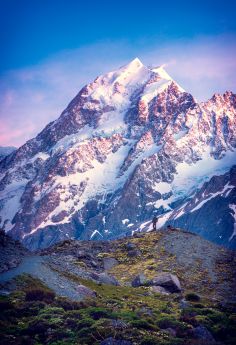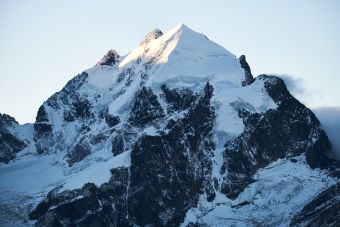
Mount Kailash, the sacred mountain peak [6,638 m] located in Tibet’s Ngari Prefecture is a world-famous pilgrim centre of Himalayas, revered by believers of Hinduism, Jainism, Buddhism and Bon followers. It is visited for circumambulation of the mountain and ritualistic bath in nearby lake Manasarovar by thousands of people every year.

Kailash -The unclimbed sacred mountain
Mount Kailash with its snow cladded peaks, worshipped as the centre of universe amazes the world for millions of years as a serene destination where devotees experience the fulfilment of soul’s journey.
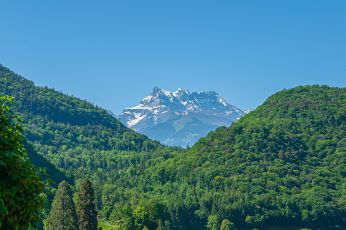
This unclimbed sacred mountain is located in Tibet in the western Trans Himalayas near Manasarovar Lake and Rakshastal. It is regarded as a symbol of spirituality and sacredness for Hinduism, Buddhism, Jainism and Bon religion of Tibet.
Mount Kailash [6638m] located in Tibet’s Ngari Prefecture is revered by Bon followers as a divine abode and the center of the universe. It is located near Lakes Manasarovar and Rakshastal.
The word ‘Kailash’ is derived from sanskrit kailasa or kelasa which means crystal. Pilgrims from China, India, Nepal, and other countries visit mount Kailash for a circumambulation of the universe. Each circumambulation is a representation of fulfilling a life-death cycle.
On the way to mount Kailash one can see numerous stupas, flag poles, Buddhist monasteries and praying stations. Many of the ancient cultural artifacts were vandalized during the Cultural Revolution of China from 1966 to 1976.
The vestiges of the artifacts visible on both sides, on your journey in quest of divine power of Kailash, may tell you the stories of civilizations and cultures of bygone era sleeping in this land.
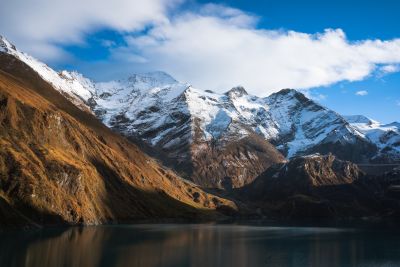
Manasarovar lake has been considered holy since time immemorial and Hindus take a ritual bath in the Manasarovar before doing circumambulation of mount Kailash. Manasarovar is the highest freshwater lake in the world.
According to Skanda Purana scripts “There are no mountains like the Himalaya, for in them are Kailas and Manasarovar. As the dew is dried up by the morning Sun, so are the sins of mankind dried up by the sight of the Himalaya
In Tibet, the mount Kailash is also known as Gang Rinpoche which means “snow jewel mountain”. Tibetan Buddhists call kailash as Kangri Rinpoche which means ‘Precious Snow Mountain’.
According to Tibetan religious texts of Bons Mount Kailash is known by several names such as Water’s Flower, Mountain of Sea Water, Nine Stacked Swastikas Mountain.
Till date Kailash Mountain peak remains unclimbed and climbing the mountain is prohibited by law due to its religious significance
Mount Kailash through the veil of myths &legends;
According to Hindu puranas and mythology texts Kailash is the centre of Universe, the home of Lord Shiva and goddess Parvati and their children. The mountain has been referred as mount Meru in Hindu scriptures and texts. Mount Meru represents stairway to heaven, where the devas reside.
The Vishnu Purana states that it lies in the centre of the world surrounded by six mountain ranges similar to a lotus, one of which is the Himalayas.
Kailash is intricately woven with the Jainism also as the first leader of Jains got enlightenment in this mountain. According to Jain scriptures, Rishabhadeva, the first Tirthankar of Jainism attained moksha (liberation) on Mount Kailash. Later Rishabhadeva’s son emperor Bharata Chakravartin had constructed three stupas and twenty-four shrines of the 24 tirthankaras in the region. He also performed a fortnight of worship termed Mahamaga and attained salvation from Kailash.
Buddhists believe that Mount Kailash is the navel of the universe. Buddhist texts describe Mount Kailash (Kailasa) as the mythological Mount Meru. Kailash is central to its cosmology, and a major pilgrimage site for some Buddhist traditions. Kailash and Manasarovar are considered as fatherly and motherly symbols in Buddhist tradition. Many destinations in the region are associated with Padmasambhava, the pioneer of Tantric Buddhism in Tibet in the 8th century CE.
Tibetan Buddhist pilgrims often chant Om mani padme hum (jewel in the lotus) and sing nyelu songs while crossing the Dolma La pass which are believe to proclaim a fraternity amongst all pilgrims who cross paths on a Kailash pilgrimage. Hinduism, Jainism, Buddhism, Bon followers converge as one entity of faith in the centre of the universe at mount Kailash.
Mount kailash is of supreme reverence for believers of Bon religion of Tibet also. For the Bons, the mountain is the abode of sky goddess Sipaimen and the mountain was the centre of the ancient Bon empire of Zhang Zhung. The followers of Bon religion of Tibet believe that the mountain is the abode of the sky goddess Sipaimen.
Geographical location
Mount Kailash is located in Ngari Prefecture, Tibet the Autonomous Region of China.
It is situated in the Gangdise Shan (also known as Kailash Range) of the Transhimalaya, in the western part of the Tibetan Plateau. The Mount Kailash peak is at an elevation of 6,638 m.
A few culturally significant rivers take origin from the western Gangdise Mountains and they include the Yarlung Tsangpo (which later becomes the Brahmaputra), the Indus, the Sutlej and the Ghaghara, a tributary of the Ganges. All these major rivers arise within a 60 km stretch in the region.
Mount Kailash is located on the banks of Manasarovar and Rakshastal lakes. Spread over an area of 320 km2.
Geology of mount Kailash
The geological analysis may show that mount kailash is a metasedimentary roof pendant supported by a base of granite. The collision of India and Asia resulted in folding, faulting, and heating of sedimentary basins. The area is a “roof pendant” or uplifted block of rock where deep crustal rocks (granites) and ocean-floor sediments (sedimentary rocks) are now exposed together at high altitudes.
The Indus headwaters area is typified by wide-scale faulting of metamorphosed late-Cretaceous to mid-Cenozoic sedimentary rocks interspersed with igneous Cenozoic granitic rocks. The headwaters are situated along the Indus-Tsangpo Suture Zone (ITSZ), where the Indian Plate collided with the Eurasian Plate. The igneous rocks are formed by the cooling of magma (molten rock) deep within the Earth’s crust during the Cenozoic era.
The Cenozoic rocks represent offshore marine limestones deposited before subduction of the Tethys oceanic crust.
Climate in the mount Kailash region
In summer the weather is fairly dry and during April to June the day time temperatures are in the range 5 to 17 °C (41 to 63 °F) and night time temperatures of 0 to 6 °C (32 to 43 °F). The region is cool even in summer.
But in the winter starting from October the temperature falls down to the freezing point ranging from −4 to 0 °C (25 to 32 °F) and further lower in the night reaching up to −20 °C (−4 °F). January is the coolest month and is covered with snow and glaciers in the Trans Himalayan region.
Monsoon rain begins from the end of June to August accompanied by freezing cold winds.
The temperature and weather of Trans Himalayas and mount Kailash are transforming under the impact of global warming as in other part of the globe. The rising temperature poses devastating impact on
The retreating glaciers and thawing of the permafrost in the Tibet region may have impact on water resources.
Furthermore, population explosion, pollution and tourism have adversely impacted the fragile ecosystem around Mount Kailash.
Pilgrimage to the sacred abode of Shiva – Kailash
It is unclear in the history when mount Kailash rose to the status of a sacred destination for pilgrimage. In the Indian subcontinent the sacred linking of landforms with divinity is evident since antiquity. In the Himalayan region crossing the borders also this tradition of sacred linking of myths is evident. Mount Kailash and other temples, monasteries in the valley testify for that.
Mount Kailash is revered as the abode of Hindu lord Shiva and by other religious sects as center of the universe.
The pilgrimage to mount Kailash involves trekking towards Lake Manasarovar and a circumambulation of Mount Kailash. The path around Mount Kailash is 53 km long. There are many stupas, flag poles, Buddhist monasteries and praying stations along the route.
The circumambulation usually begins and ends at Darchen, a small outpost located at an elevation of 4,670 m.
Each circumambulation of mount Kailash is symbolic of a fulfilled a life-death cycle.
Hindus take a ritual bath in the Manasarovar before doing circumambulation. The circumambulation is made in a clockwise direction by Hindus, Buddhists, and Jains, while Bonpos circumambulate the mountain in a counterclockwise direction. But setting foot on the slopes of the mountain or attempting to climb it is forbidden by law due to the religious significance of the mountain.
Religious pilgrimages to Mount Kailas and Manasarovar were allowed by China after its occupation of Tibet in 1950-51.
While pilgrimage from India was guaranteed by the 1954 Sino-Indian Agreement, access was restricted after the subsequent 1959 Tibetan uprising and the borders were closed after the Sino-Indian War in 1962.
After a pause of around two decades pilgrimage from India to Mount Kailash was resumed in 1981 after an agreement between the governments of India and China.
Later in 2020 the pandemic covid shut the route to mount Kailash and Manasarovar for around three successive years.
The route was re-opened in 2023 with new regulations.
How can you make a pilgrimage to mount kailash? [Kailash manasarovar yatra]
The pilgrimage or journey to mount Kailash is facilitated by Govt of India since 2015. The pilgrim tourists may have to apply in advance to the Ministry of External Affairs and specific number of passes will be issued to them and preference given to those who are visiting for the first time visitors.
In India, the applications are to be submitted for Kailash manasarovar yatra from June and September.
Pilgrims from India travel through two routes : with border crossings at Lipu Lekh pass in Uttarakhand and the Nathu La pass in Sikkim.
Visit mount Kailash from Nepal
Since 2015, the pilgrimage from Nepal is conducted through the Humla district in northwestern Nepal. Mount Kailash is visible from the Lapcha La pass above the Limi valley also.
Another route exists through the crossing at Rasuwa-Gyirong. Pilgrims could reach Lhasa by air before the journey to Lake Manasarovar.
The pilgrimage to mount Kailash involves trekking towards Lake Manasarovar and a circumambulation of Mount Kailash. The path around Mount Kailash is 53 km long.
The circumambulation usually begins and ends at Darchen, a small outpost located at an elevation of 4,670 m.
Trekking around the mountain can be made on foot with the help of a pony or domestic yak. The circumambulation takes three days on average with the first day trek from Darchen to Dirapuk gompa for about 14 km. The journey is resumed from Dirpauk to Zutulphuk via the Drolma pass for 19 km on the second day and the final day trekking back to Darchen .
The mystery of unclimbed mountain.
Mount Kailash had amazed many travellers on expeditions in the past centuries. In the beginning there were attempts by some trekking enthusiasts to climb the mountain. But adverse weather, snow fall paused hindrances and they abandoned the idea of trekking on the mountain. Later due to the growing religious significance and sacredness assigned by believers to the mountain, attempts to climb mount Kailash is forbidden by law.
written by dr sanjana p souparnika
image courtesy freepik.com